
IMAGES TAKEN NEAR TO
Broad Plain, BRISTOL, BS2 0JP
Introduction
This page details the photographs taken nearby to Broad Plain, BS2 0JP by members of the Geograph project.
The Geograph project started in 2005 with the aim of publishing, organising and preserving representative images for every square kilometre of Great Britain, Ireland and the Isle of Man.

There are currently over 7.5m images from over14,400 individuals and you can help contribute to the project by visiting https://www.geograph.org.uk
Image Map
Images are licensed for reuse under creativecommons.org/licenses/by-sa/2.0
Notes
- Clicking on the map will re-center to the selected point.
- The higher the marker number, the further away the image location is from the centre of the postcode.
Image Listing (651 Images Found)
Images are licensed for reuse under creativecommons.org/licenses/by-sa/2.0
Image
Details
Distance
2
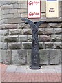
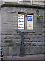
Millennium milepost in Straight Street
On the Bath to Bristol Cycleway (NCN4)
Image: © John M
Taken: 13 Dec 2012
0.02 miles
3
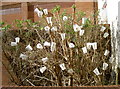
Early blooms
Perhaps it is a sign of global warming but these polystyrene cup trees don't normally come out until March...
Image: © Neil Owen
Taken: 27 Jan 2012
0.02 miles
4
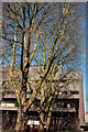
Broad Plain, Bristol
Looking across the triangular square to 1 Temple Way (architect:John Collins).
Image: © Derek Harper
Taken: 5 Apr 2018
0.02 miles
5
Straight along the road
This part of the road network is now pedestrianised, hence the cast cycle route marker.
Image: © Neil Owen
Taken: 27 Jan 2012
0.02 miles
6
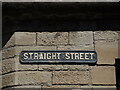
Straight Street sign
Cracked and flaky, the sign is not that old. Up until the late 1800s, it was known as Strait Street.
Image: © Neil Owen
Taken: 26 Apr 2022
0.02 miles
7
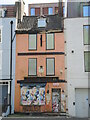
Squeezing the devil
A narrow old pub is now crowded by its neighbours. The Printer's Devil is a term used in the printing trade for a young apprentice or office worker. Just opposite was the Bristol Evening Post offices and printworks, that opened in the 1970s (it is now closed). Before that the pub was known as the Queen's Head and was founded in the late eighteenth century.
Look closely and you will note that the building to the right is only a few years old (part of the Glassfields development). The pub and the building to the left of shot are perhaps the last of a line of old buildings and houses that used to line this part of Bristol. They once crowded all along Narrow Plain and Broad Plain, but most were lost in the post-war development - particularly the construction of the multi-lane road network. Hence the pub's survival is somewhat diminished by the forlorn appearance.
Image: © Neil Owen
Taken: 26 Apr 2022
0.03 miles
8
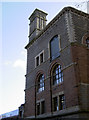
Long way up
The Unity Street area of Bristol still retains a number of old warehouse and factory buildings. This one has an interesting arrangement of doors and openings, even if they are a fair way above the ground.
Image: © Neil Owen
Taken: 27 Jan 2012
0.03 miles

10
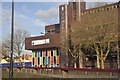
Bristol : 1 Temple Way
1 Temple Way in Bristol is a building for offices and such.
Image: © Lewis Clarke
Taken: 1 Feb 2013
0.03 miles