IMAGES TAKEN NEAR TO
Lamb Street, BRISTOL, BS2 0DR
Introduction
This page details the photographs taken nearby to Lamb Street, BS2 0DR by members of the Geograph project.
The Geograph project started in 2005 with the aim of publishing, organising and preserving representative images for every square kilometre of Great Britain, Ireland and the Isle of Man.

There are currently over 7.5m images from over14,400 individuals and you can help contribute to the project by visiting https://www.geograph.org.uk
Image Map
Images are licensed for reuse under creativecommons.org/licenses/by-sa/2.0
Notes
- Clicking on the map will re-center to the selected point.
- The higher the marker number, the further away the image location is from the centre of the postcode.
Image Listing (303 Images Found)
Images are licensed for reuse under creativecommons.org/licenses/by-sa/2.0
Image
Details
Distance
1
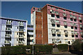
Flats, Lamb Street, Bristol
Langton House (left) and Haviland House are across the road from Image
Image: © Derek Harper
Taken: 5 Apr 2018
0.01 miles
2
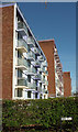
Flats, Lamb Street, Bristol
A more oblique view of the blocks shown in Image]: Langton House (left) and Haviland House.
Image: © Derek Harper
Taken: 5 Apr 2018
0.01 miles
3
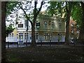
The Seven Ways
Disused pub in a shady spot on Redcross Street.
Image: © Thomas Nugent
Taken: 7 Sep 2010
0.02 miles
4
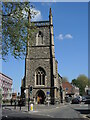
Old St Jude's
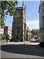
The church of St Jude the Apostle stands at an important road junction in east Bristol. The area was originally an open section known as Point's Pool, which was developed in the nineteenth century. Occupying a former bull-baiting ring site, the church was built in 1844-49 to the designs of S.B.Gabriel. Its service ended towards the turn of the twentieth century, leaving the building derelict and disused. In 2004-5 it was converted into apartments.
Image: © Neil Owen
Taken: 26 Apr 2022
0.03 miles
5
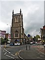
St Jude's Church
Built on the site of the Bullring, St Jude’s church was erected in 1844-49 to the designs of S.B.Gabriel. It stands today – converted into flats – at the beginning of the Old Market one-way system. It is listed Grade II
Image: © Eirian Evans
Taken: 25 Jun 2023
0.03 miles
7
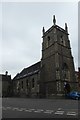
Church on Lamb Street
St. Judes Church between Bragg's Lane and Lamb Street.
Image: © DS Pugh
Taken: 27 Jun 2017
0.03 miles
8
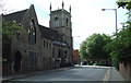
Lamb Street
The church has been converted to flats.
Image: © Thomas Nugent
Taken: 7 Sep 2010
0.03 miles
9
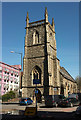
Former Church of St Jude, Bristol
More fully, the Church of St Jude the Apostle with St Matthias-on-the-Weir. The image adds little to Image, but gives the opportunity to provide a link to the listed building description at https://www.historicengland.org.uk/listing/the-list/list-entry/1204207 : "1849. By SB Gabriel ... Decorated Gothic Revival style." On the left is part of Haviland House.
Image: © Derek Harper
Taken: 5 Apr 2018
0.03 miles
10
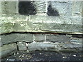
Benchmark on St Judes Church, Bragg's Lane
Ordnance Survey cut mark benchmark which is indicated on 1884 map and described on the Bench Mark Database at http://www.bench-marks.org.uk/bm28937
Image: © Roger Templeman
Taken: 14 Aug 2010
0.03 miles