IMAGES TAKEN NEAR TO
West Street, BRISTOL, BS2 0BH
Introduction
This page details the photographs taken nearby to West Street, BS2 0BH by members of the Geograph project.
The Geograph project started in 2005 with the aim of publishing, organising and preserving representative images for every square kilometre of Great Britain, Ireland and the Isle of Man.

There are currently over 7.5m images from over14,400 individuals and you can help contribute to the project by visiting https://www.geograph.org.uk
Image Map (Loading...)


Getting Data...Please wait
Leaflet Map data © OpenStreetMap
Images are licensed for reuse under creativecommons.org/licenses/by-sa/2.0
Notes
- Clicking on the map will re-center to the selected point.
- The higher the marker number, the further away the image location is from the centre of the postcode.
Image Listing (238 Images Found)
Images are licensed for reuse under creativecommons.org/licenses/by-sa/2.0
Image
Details
Distance
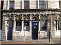
1
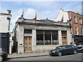
The Old Market Assembly
Originally a branch of Lloyd's Bank built in the nineteenth century, but closed its doors to customers. Instead, the building has been used as a restaurant and is now also home to a theatre group. Interestingly, the carved stonework states it was established in (Roman numerals) in 1778; Taylors & Lloyds was opened as a private bank in Birmingham in June 1765.
Image: © Neil Owen
Taken: 5 May 2022
0.02 miles
2
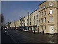
Shops in Midland Road
Run down shops and former pub.
Image: © John M
Taken: 1 Feb 2011
0.04 miles
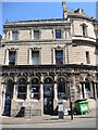
3
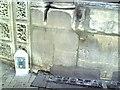
Benchmark on The Palace Hotel
Ordnance Survey cut mark bench described on the Bench Mark Database at http://www.bench-marks.org.uk/bm28933.
Image: © Roger Templeman
Taken: 14 Aug 2010
0.05 miles
4
Ordnance Survey Cut Mark
This OS cut mark can be found on the Palace Hotel, West Street. It marks a point 20.196m above mean sea level.
Image: © Adrian Dust
Taken: 26 Jan 2020
0.05 miles
5
Gin Palace
A side view of the Palace Hotel, a well-known watering hole. See Image] for a view of the entrance, being on the corner of the junction as it is.
Image: © Neil Owen
Taken: 27 Jan 2012
0.05 miles
6
The Palace Hotel
A view of the Lawford Street side of the old gin palace. It's a pity some of the intricate details are given little respect.
Image: © Neil Owen
Taken: 26 Apr 2022
0.05 miles
7
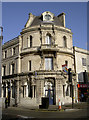
Waiting in vain
This is the Palace Hotel, previously the Gin Palace, and before that the Station Hotel. It was built speculatively in 1869 for the booming railway passenger trade brought locally by Bristol's new terminus. Sadly, the station was instead built at Temple Meads and so this ornate Victorian 'waiting room' never made that much money. Currently its owners have maintained the many decorative and elaborate features, especially the upper bar floor - which is actually parallel with the slope of the road outside!
See Image] for the two supporting figures holding the roof up, and Image] for the degree of the slope.
Image: © Neil Owen
Taken: 27 Jan 2012
0.05 miles
8
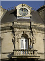
Time to stay?
As befits a hotel dependant on railway guests, the Palace Hotel has a clock atop its roof. Built in 1869, the hotel has many remarkable features, both inside and outside as seen here. The satellite dish is not Victorian, though.
See Image] for the side view of the first floor.
Image: © Neil Owen
Taken: 27 Jan 2012
0.05 miles
9
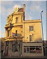
Former Palace Hotel, Bristol
The left part of this building, on the corner of West Street and Lawford Street, was "originally the Railway Hotel, ... built in 1869-70 and ... a speculative development by Thomas Morgan designed to take advantage of a new railway station planned nearby" http://list.english-heritage.org.uk/resultsingle.aspx?uid=1219436&searchtype=mapsearch .
Image: © Derek Harper
Taken: 22 Nov 2013
0.05 miles
10
Hide Market, Waterloo Road
An unusual name for a small business complex.
Image: © Stephen Craven
Taken: 24 Jun 2017
0.05 miles