IMAGES TAKEN NEAR TO
Cadbury Halt, BRISTOL, BS20 8QD
Introduction
This page details the photographs taken nearby to Cadbury Halt, BS20 8QD by members of the Geograph project.
The Geograph project started in 2005 with the aim of publishing, organising and preserving representative images for every square kilometre of Great Britain, Ireland and the Isle of Man.

There are currently over 7.5m images from over14,400 individuals and you can help contribute to the project by visiting https://www.geograph.org.uk
Image Map
Images are licensed for reuse under creativecommons.org/licenses/by-sa/2.0
Notes
- Clicking on the map will re-center to the selected point.
- The higher the marker number, the further away the image location is from the centre of the postcode.
Image Listing (11 Images Found)
Images are licensed for reuse under creativecommons.org/licenses/by-sa/2.0
Image
Details
Distance
1
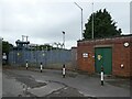
Electricity sub-station, Weston in Gordano
Image: © Roger Cornfoot
Taken: 17 Aug 2022
0.03 miles
3
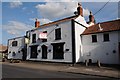
The White Hart, Weston in Gordano
The White Hart, in the village of Weston in Gordano, not sure if it is currently open as it is to let.
Image: © Philip Halling
Taken: 17 Jul 2014
0.14 miles
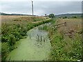
5
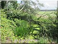
Rhyne on Weston Moor
Looking East from Weston Drove.
Image: © Dr Duncan Pepper
Taken: 20 Aug 2013
0.16 miles
7
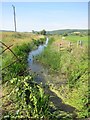
Rhyne on Weston Moor
Looking West from Weston Drove.
Image: © Dr Duncan Pepper
Taken: 20 Aug 2013
0.18 miles
9
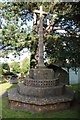
Cross, Weston in Gordano
Cross in Weston in Gordano churchyard.
Image: © Philip Halling
Taken: 17 Jul 2014
0.24 miles
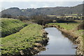
10
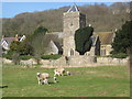
Weston-in-Gordano church
The field in the foreground is the old village animal pound, still in use today.
Image: © Dr Duncan Pepper
Taken: 2 Mar 2009
0.24 miles