IMAGES TAKEN NEAR TO
Clevedon Road, BRISTOL, BS20 8PU
Introduction
This page details the photographs taken nearby to Clevedon Road, BS20 8PU by members of the Geograph project.
The Geograph project started in 2005 with the aim of publishing, organising and preserving representative images for every square kilometre of Great Britain, Ireland and the Isle of Man.

There are currently over 7.5m images from over14,400 individuals and you can help contribute to the project by visiting https://www.geograph.org.uk
Image Map (Loading...)


Getting Data...Please wait
Leaflet Map data © OpenStreetMap
Images are licensed for reuse under creativecommons.org/licenses/by-sa/2.0
Notes
- Clicking on the map will re-center to the selected point.
- The higher the marker number, the further away the image location is from the centre of the postcode.
Image Listing (40 Images Found)
Images are licensed for reuse under creativecommons.org/licenses/by-sa/2.0
Image
Details
Distance
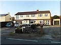
2
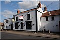
The White Hart, Weston in Gordano
The White Hart, in the village of Weston in Gordano, not sure if it is currently open as it is to let.
Image: © Philip Halling
Taken: 17 Jul 2014
0.06 miles
3
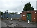
Electricity sub-station, Weston in Gordano
Image: © Roger Cornfoot
Taken: 17 Aug 2022
0.08 miles
4
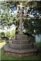
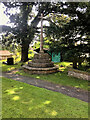
Cross, Weston in Gordano
Cross in Weston in Gordano churchyard.
Image: © Philip Halling
Taken: 17 Jul 2014
0.18 miles
5
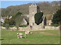
Weston-in-Gordano church
The field in the foreground is the old village animal pound, still in use today.
Image: © Dr Duncan Pepper
Taken: 2 Mar 2009
0.18 miles
6
SS Peter & Paul, Weston in Gordano: noticeboard
Image: © Basher Eyre
Taken: 24 Jun 2017
0.18 miles
7
Cross in the Churchyard of SS Peter and Paul, Weston in Gordano
Image: © David Dixon
Taken: 21 Jul 2021
0.20 miles
8
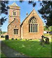
The Church of St Peter and St Paul, Weston in Gordano
Church, mostly dating from the 15th century although the tower and porch are earlier (ca 1300). Nineteenth century modifications. Grade I listed building (List Entry Number: 1129139 https://historicengland.org.uk/listing/the-list/list-entry/1129139 Historic England).
Image: © David Dixon
Taken: 21 Jul 2021
0.20 miles
9
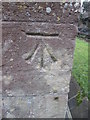
Ordnance Survey Cut Mark
This OS cut mark can be found on the east face of St Peter & St Paul's Church. It marks a point 17.520m above mean sea level.
Image: © Adrian Dust
Taken: 6 Mar 2016
0.20 miles
10

Inside SS Peter & Paul, Weston in Gordano (IX)
Image: © Basher Eyre
Taken: 24 Jun 2017
0.20 miles