IMAGES TAKEN NEAR TO
Northfield Road, BRISTOL, BS20 8LE
Introduction
This page details the photographs taken nearby to Northfield Road, BS20 8LE by members of the Geograph project.
The Geograph project started in 2005 with the aim of publishing, organising and preserving representative images for every square kilometre of Great Britain, Ireland and the Isle of Man.

There are currently over 7.5m images from over14,400 individuals and you can help contribute to the project by visiting https://www.geograph.org.uk
Image Map
Images are licensed for reuse under creativecommons.org/licenses/by-sa/2.0
Notes
- Clicking on the map will re-center to the selected point.
- The higher the marker number, the further away the image location is from the centre of the postcode.
Image Listing (12 Images Found)
Images are licensed for reuse under creativecommons.org/licenses/by-sa/2.0
Image
Details
Distance
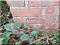
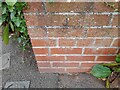
3
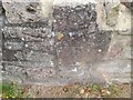
Ordnance Survey Cut Mark
This OS cut mark can be found on the wall of No284 Down Road. It marks a point 97.405m above mean sea level.
Image: © Adrian Dust
Taken: 20 Aug 2022
0.11 miles
5
Ordnance Survey Cut Mark
This OS cut mark can be found on the small brick building SW side of Valley Road. It marks a point 106.287m above mean sea level.
Image: © Adrian Dust
Taken: 20 Aug 2022
0.15 miles
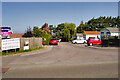
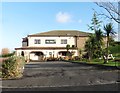
8
Charlcombe Rise.
New houses at Charlcombe Rise
Image: © Adrian and Janet Quantock
Taken: 4 Feb 2006
0.19 miles
9
Ordnance Survey Cut Mark
This OS cut mark can be found on the wall of No385 Nore Road. It marks a point 74.124m above mean sea level.
Image: © Adrian Dust
Taken: 20 Aug 2022
0.19 miles
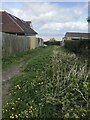
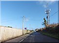
10
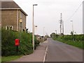
Down Road
Descending from the indistinct and built up summit of Weston Down.
Image: © Richard Webb
Taken: 18 Apr 2011
0.23 miles