IMAGES TAKEN NEAR TO
Valley Road, BRISTOL, BS20 8JZ
Introduction
This page details the photographs taken nearby to Valley Road, BS20 8JZ by members of the Geograph project.
The Geograph project started in 2005 with the aim of publishing, organising and preserving representative images for every square kilometre of Great Britain, Ireland and the Isle of Man.

There are currently over 7.5m images from over14,400 individuals and you can help contribute to the project by visiting https://www.geograph.org.uk
Image Map (Loading...)


Getting Data...Please wait
Leaflet Map data © OpenStreetMap
Images are licensed for reuse under creativecommons.org/licenses/by-sa/2.0
Notes
- Clicking on the map will re-center to the selected point.
- The higher the marker number, the further away the image location is from the centre of the postcode.
Image Listing (8 Images Found)
Images are licensed for reuse under creativecommons.org/licenses/by-sa/2.0
Image
Details
Distance
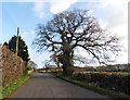
1

Road, Weston Lodge
There is a pipeline marker on the left.
Image: © Richard Webb
Taken: 18 Apr 2011
0.12 miles
3
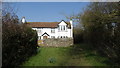
Brockley Cottage, Blackberry Lane, Weston in Gordano
Image: © Colin Park
Taken: 14 Mar 2016
0.15 miles
4
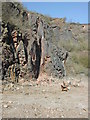
Sheer cliffs
West end of Black Rock Quarry
Image: © FollowMeChaps
Taken: 19 Mar 2006
0.16 miles
5
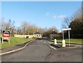
HQ, Avon and Somerset Police and Fire Service
Image: © Roger Cornfoot
Taken: 9 Dec 2019
0.19 miles
6
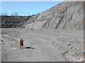
Black Rocks Quarry
East end looking Westwards
Image: © FollowMeChaps
Taken: 20 Mar 2006
0.21 miles
7
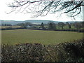
South across grid square
Black Rock Quarry is behind second field at left of picture
Image: © FollowMeChaps
Taken: 20 Mar 2006
0.21 miles
8
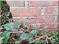
Ordnance Survey Cut Mark
This OS cut mark can be found on the small brick building SW side of Valley Road. It marks a point 106.287m above mean sea level.
Image: © Adrian Dust
Taken: 20 Aug 2022
0.24 miles