IMAGES TAKEN NEAR TO
St. Augustines Close, BRISTOL, BS20 8JH
Introduction
This page details the photographs taken nearby to St. Augustines Close, BS20 8JH by members of the Geograph project.
The Geograph project started in 2005 with the aim of publishing, organising and preserving representative images for every square kilometre of Great Britain, Ireland and the Isle of Man.

There are currently over 7.5m images from over14,400 individuals and you can help contribute to the project by visiting https://www.geograph.org.uk
Image Map
Images are licensed for reuse under creativecommons.org/licenses/by-sa/2.0
Notes
- Clicking on the map will re-center to the selected point.
- The higher the marker number, the further away the image location is from the centre of the postcode.
Image Listing (11 Images Found)
Images are licensed for reuse under creativecommons.org/licenses/by-sa/2.0
Image
Details
Distance
1
Redcliff Bay Methodist Church
Image: © Adrian and Janet Quantock
Taken: 4 Feb 2006
0.05 miles
2
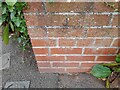
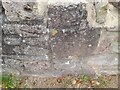
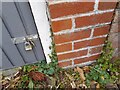
Ordnance Survey Cut Mark
This OS cut mark can be found on the wall of No385 Nore Road. It marks a point 74.124m above mean sea level.
Image: © Adrian Dust
Taken: 20 Aug 2022
0.05 miles
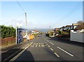
4
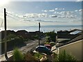
Queens Road, Portishead
Looking down towards the estuary.
Image: © David Dixon
Taken: 16 Jul 2021
0.12 miles
5
Ordnance Survey Cut Mark
This OS cut mark can be found on the wall of No284 Down Road. It marks a point 97.405m above mean sea level.
Image: © Adrian Dust
Taken: 20 Aug 2022
0.14 miles
6
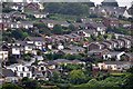
Portishead : Portishead Scenery
Looking into the town of Portishead in North Somerset.
Image: © Lewis Clarke
Taken: 24 Jul 2015
0.16 miles
7
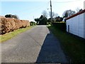
Weston Down
Almost a one out of ten even on a great sunny day. Various side roads higher than Down Road, I would probably choose the top of Harmony Drive.
Name: Weston Down
Hill number: 5433
Height: 113m / 371ft
Area: 41: South Central England
Class: Hu
Grid ref: ST447757 (est)
Drop: 100m
Col: 13m ST416722
Image: © Rude Health
Taken: 26 Mar 2012
0.23 miles
8
Ordnance Survey Cut Mark
This OS cut mark can be found on the garage of No333 Nore Road. It marks a point 43.141m above mean sea level.
Image: © Adrian Dust
Taken: 20 Aug 2022
0.23 miles
9
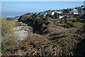
Redcliff Bay
Houses overlooking the Bristol Channel at Redcliff Bay.
Image: © Philip Halling
Taken: 13 Mar 2010
0.24 miles