IMAGES TAKEN NEAR TO
Crest Heights, BRISTOL, BS20 8FE
Introduction
This page details the photographs taken nearby to Crest Heights, BS20 8FE by members of the Geograph project.
The Geograph project started in 2005 with the aim of publishing, organising and preserving representative images for every square kilometre of Great Britain, Ireland and the Isle of Man.

There are currently over 7.5m images from over14,400 individuals and you can help contribute to the project by visiting https://www.geograph.org.uk
Image Map
Images are licensed for reuse under creativecommons.org/licenses/by-sa/2.0
Notes
- Clicking on the map will re-center to the selected point.
- The higher the marker number, the further away the image location is from the centre of the postcode.
Image Listing (27 Images Found)
Images are licensed for reuse under creativecommons.org/licenses/by-sa/2.0
Image
Details
Distance
1
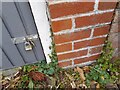
Ordnance Survey Cut Mark
This OS cut mark can be found on the garage of No333 Nore Road. It marks a point 43.141m above mean sea level.
Image: © Adrian Dust
Taken: 20 Aug 2022
0.07 miles
2
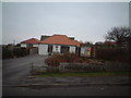
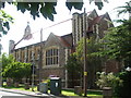
Redcliff Bay Methodist Church
Image: © Adrian and Janet Quantock
Taken: 4 Feb 2006
0.12 miles
3
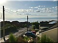
Queens Road, Portishead
Looking down towards the estuary.
Image: © David Dixon
Taken: 16 Jul 2021
0.13 miles
5
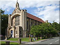
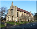
St Nicholas, Portishead
The church was founded in 1911 as part of the National Nautical School that lies just down the hillside, overlooking the sea. It served the many young boys who were brought up in the institution until the school closed in 1982. It is now partly associated with the United Reformed Church. See Image] for the statues over the entrance.
Image: © Neil Owen
Taken: 19 Jul 2020
0.16 miles
6
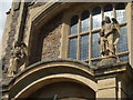
Angels looking over the children
The entrance to St Nicholas on Nore Road features these winged guardians.
Image: © Neil Owen
Taken: 19 Jul 2020
0.16 miles
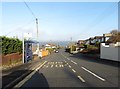
7
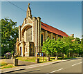
St Nicholas' Church, Nore Rd
St Nicholas', built in 1911, was the National Nautical School College Chapel until 1980. It was purchased by the Portishead Parish in 1985. The College used the training ship ‘Formidable’, an old wooden warship used as a reformatory from 1869-1906 for up to 300 boys from the streets of Bristol, who were trained as seamen. When it was replaced, part of the ship was incorporated into the main altar of St Nicholas' Church. It is a Grade II listed building (List Entry Number: 1255545 https://historicengland.org.uk/listing/the-list/list-entry/1255545 Historic England).
Image: © David Dixon
Taken: 20 Jul 2021
0.17 miles
8
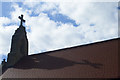
Shadow of the cross on St Nicholas
The roof tiles are cast with the sun and the cross.
Image: © Neil Owen
Taken: 19 Jul 2020
0.17 miles
10
St Nicholas church, Nore Road
This large and impressive church has a local connection to the old Nautical School just up the hill. Originally, a training ship was moored out in the Bristol Channel ‘to train boys who would otherwise through poverty or parental neglect, or being orphans, be left destitute and homeless, and in danger of being contaminated with vice and crime’. In other words it was a floating orphanage in all but name.
Having gradually rotted over time a Mr Harry Fedden, a Bristol philanthropist, was a prime mover in founding a land-based school to replace the wooden ship. That opened in 1906 and this new church for the boys was founded in 1911, using stone from the Chappell Charity quarry. A benchmark can be seen on the church's east angle - see Image
St Nicholas is the patron saint of sailors and young boys.
Image: © Neil Owen
Taken: 19 Jul 2020
0.18 miles