IMAGES TAKEN NEAR TO
Royal Portbury Dock, BRISTOL, BS20 7XW
Introduction
This page details the photographs taken nearby to Royal Portbury Dock, BS20 7XW by members of the Geograph project.
The Geograph project started in 2005 with the aim of publishing, organising and preserving representative images for every square kilometre of Great Britain, Ireland and the Isle of Man.

There are currently over 7.5m images from over14,400 individuals and you can help contribute to the project by visiting https://www.geograph.org.uk
Image Map (Loading...)


Getting Data...Please wait
Leaflet Map data © OpenStreetMap
Images are licensed for reuse under creativecommons.org/licenses/by-sa/2.0
Notes
- Clicking on the map will re-center to the selected point.
- The higher the marker number, the further away the image location is from the centre of the postcode.
Image Listing (6 Images Found)
Images are licensed for reuse under creativecommons.org/licenses/by-sa/2.0
Image
Details
Distance
5
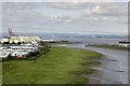
Nelson Point, Avonmouth, Bristol.
Taken in the Swash Channel leading to the River Avon. Avonmouth Dock is behind.
Image: © Rick Crowley
Taken: 15 Aug 2016
0.21 miles
6

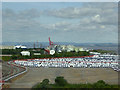
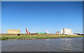
Wraxall and Failand : Royal Portbury Dock
Looking towards the Royal Portbury Dock.
Image: © Lewis Clarke
Taken: 26 Jun 2020
0.23 miles