IMAGES TAKEN NEAR TO
Gordano Quay, Royal Portbury Dock, BRISTOL, BS20 7XF
Introduction
This page details the photographs taken nearby to Gordano Quay, Royal Portbury Dock, BS20 7XF by members of the Geograph project.
The Geograph project started in 2005 with the aim of publishing, organising and preserving representative images for every square kilometre of Great Britain, Ireland and the Isle of Man.

There are currently over 7.5m images from over14,400 individuals and you can help contribute to the project by visiting https://www.geograph.org.uk
Image Map
Images are licensed for reuse under creativecommons.org/licenses/by-sa/2.0
Notes
- Clicking on the map will re-center to the selected point.
- The higher the marker number, the further away the image location is from the centre of the postcode.
Image Listing (6 Images Found)
Images are licensed for reuse under creativecommons.org/licenses/by-sa/2.0
Image
Details
Distance
1
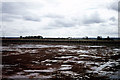
The Royal Portbury Dock prior to flooding
A rare opportunity to visit The Royal Portbury Dock prior to it being flooded.
Image: © Colin Park
Taken: 16 Aug 1975
0.05 miles
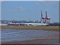
2
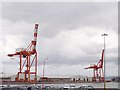
Cranes on Gordano quay
These two large cranes stand on Gordano Quay in Royal Portbury dock, and are used for unloading heavy goods such as metals and steel. The right hand crane stands in grid square ST4977.
Image: © Sharon Loxton
Taken: 31 Jul 2006
0.07 miles
3
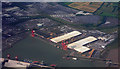
The Royal Portbury Dock
View of Portbury Docks seen from the air.
Image: © Peter McDermott
Taken: 26 Aug 2009
0.11 miles
4
Avonmouth and the Bristol Channel
Some of the heavy industrial area that welcomes shipping from all over the world.
Image: © Neil Owen
Taken: 1 Nov 2018
0.14 miles
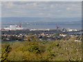
5
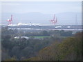
Royal Portbury Dock, Bristol
A long view of Royal Portbury Dock, Bristol, taken from the Sea Walls, Clifton Down, showing the River Severn and the Welsh coast in the background.
Image: © Shaun O'Sullivan
Taken: 1 Nov 2009
0.21 miles
6
Avonmouth - Container Port
Gordano Quay sheds and cranes seen from Portishead.
Image: © Colin Smith
Taken: 25 Mar 2016
0.24 miles