IMAGES TAKEN NEAR TO
High Street, BRISTOL, BS20 7TW
Introduction
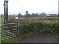
This page details the photographs taken nearby to High Street, BS20 7TW by members of the Geograph project.
The Geograph project started in 2005 with the aim of publishing, organising and preserving representative images for every square kilometre of Great Britain, Ireland and the Isle of Man.

There are currently over 7.5m images from over14,400 individuals and you can help contribute to the project by visiting https://www.geograph.org.uk
Image Map (Loading...)


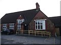
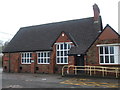
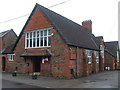
Getting Data...Please wait
Leaflet Map data © OpenStreetMap
Images are licensed for reuse under creativecommons.org/licenses/by-sa/2.0
Notes
- Clicking on the map will re-center to the selected point.
- The higher the marker number, the further away the image location is from the centre of the postcode.
Image Listing (91 Images Found)
Images are licensed for reuse under creativecommons.org/licenses/by-sa/2.0
Image
Details
Distance
1

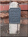
Old Direction Sign - Signpost by High Street, Portbury
Pyramid finial - 2 arms; Somerset SCC pyramid by High Street (former A369), in parish of Easton in Gordano (North Somerset District), Portbury, junction of High Street with Mill Lane, on bank.
Surveyed
Milestone Society National ID: SO_ST5075
Image: © Alan Rosevear
Taken: 24 Sep 2012
0.02 miles
2
A large guard on the corner
The bell-like object is a guard to protect the property on what is a rather sharp and awkward corner in Portbury.
Image: © Neil Owen
Taken: 27 Dec 2019
0.02 miles
3
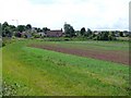
Portbury
This is the eastern side of Portbury viewed from Church lane. The church is isolated from the village by these fields. High St runs along the left and the prominent building is the old school.
Image: © Nigel Mykura
Taken: 10 Jun 2011
0.03 miles
4
Electrical utility marker
An old (but presumably still revelant) electricity cable marker outside the village hall.
Image: © Neil Owen
Taken: 27 Dec 2019
0.04 miles
5
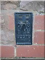
S9976: Portbury, Village Club
Ordnance Survey flush bracket by the foot of the access ramp to the club. See https://www.geograph.org.uk/photo/6090498 for a wider view and https://www.bench-marks.org.uk/bm22193 for details of the mark.
Image: © Brian Westlake
Taken: 21 Feb 2019
0.05 miles
6
Portbury, Village Club
There is an Ordnance Survey flush bracket by the foot of the access ramp to the club. See https://www.geograph.org.uk/photo/6090497 for a closer view and https://www.bench-marks.org.uk/bm22193 for details of the mark.
Image: © Brian Westlake
Taken: 21 Feb 2019
0.05 miles
7
Portbury village hall
The village was gifted the site by Colonel and Lady Brittan in 1892. It remains a central part of the local community. Although largely run by volunteers, the hall is actually a not-for-profit Company Limited by Guarantee.
Image: © Neil Owen
Taken: 27 Dec 2019
0.05 miles
8
Portbury's hall
Founded by local landowners in 1892 and still a vital part of the community.
Image: © Neil Owen
Taken: 27 Dec 2019
0.05 miles
9
MoT parking
Despite the rural setting (including the church of St Mary in the background), the sign allows motorists to use the car park of the village hall; the garage is actually right beside the hall on the opposite side.
Image: © Neil Owen
Taken: 27 Dec 2019
0.06 miles
10
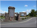
War Memorial Portbury
The war memorial sits at the junction of High St and Station road next to the village green. In the background are the houses of Priory Rd.
Image: © Nigel Mykura
Taken: 10 Jun 2011
0.07 miles