IMAGES TAKEN NEAR TO
Wharf Lane, BRISTOL, BS20 7TD
Introduction
This page details the photographs taken nearby to Wharf Lane, BS20 7TD by members of the Geograph project.
The Geograph project started in 2005 with the aim of publishing, organising and preserving representative images for every square kilometre of Great Britain, Ireland and the Isle of Man.

There are currently over 7.5m images from over14,400 individuals and you can help contribute to the project by visiting https://www.geograph.org.uk
Image Map (Loading...)


Getting Data...Please wait
Leaflet Map data © OpenStreetMap
Images are licensed for reuse under creativecommons.org/licenses/by-sa/2.0
Notes
- Clicking on the map will re-center to the selected point.
- The higher the marker number, the further away the image location is from the centre of the postcode.
Image Listing (29 Images Found)
Images are licensed for reuse under creativecommons.org/licenses/by-sa/2.0
Image
Details
Distance
1

Portbury : Wharf Villas
Looking towards a barn at Wharf Villas.
Image: © Lewis Clarke
Taken: 2 Jun 2020
0.02 miles
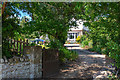
2

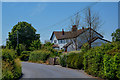
Portbury : Springfield
A house off Sheepway.
Image: © Lewis Clarke
Taken: 2 Jun 2020
0.04 miles
3
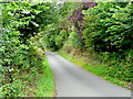
Wharf Lane
This leads to Portbury Wharf from Sheepway.
Image: © Jonathan Billinger
Taken: 16 Jul 2009
0.04 miles
4
Portbury : Springfield
Looking towards a driveway to Springfield.
Image: © Lewis Clarke
Taken: 2 Jun 2020
0.05 miles
5
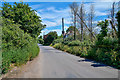
Portbury : Sheepway
Looking along Sheepway in the parish of Portbury.
Image: © Lewis Clarke
Taken: 2 Jun 2020
0.06 miles
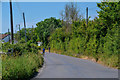
6

Portbury : Wharf Lane
Wharf Lane passing Springfield Cottage.
Image: © Lewis Clarke
Taken: 2 Jun 2020
0.08 miles
7
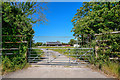
Portbury : Portbury House
A track heading beyond the gate to Portbury House.
Image: © Lewis Clarke
Taken: 2 Jun 2020
0.09 miles
8
Portbury : Sheepway
Looking along Sheepway.
Image: © Lewis Clarke
Taken: 2 Jun 2020
0.10 miles
9
Portbury : Sheepway
Looking along Sheepway.
Image: © Lewis Clarke
Taken: 2 Jun 2020
0.11 miles
