IMAGES TAKEN NEAR TO
St. Marys Road, BRISTOL, BS20 7QR
Introduction
This page details the photographs taken nearby to St. Marys Road, BS20 7QR by members of the Geograph project.
The Geograph project started in 2005 with the aim of publishing, organising and preserving representative images for every square kilometre of Great Britain, Ireland and the Isle of Man.

There are currently over 7.5m images from over14,400 individuals and you can help contribute to the project by visiting https://www.geograph.org.uk
Image Map
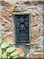
Images are licensed for reuse under creativecommons.org/licenses/by-sa/2.0
Notes
- Clicking on the map will re-center to the selected point.
- The higher the marker number, the further away the image location is from the centre of the postcode.
Image Listing (26 Images Found)
Images are licensed for reuse under creativecommons.org/licenses/by-sa/2.0
Image
Details
Distance
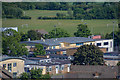
2
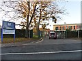
Portishead, Gordano School
Secondary school on Clevedon Road. Much of the site is under redevelopment. http://www.gordanoschool.org.uk/why-choose-gordano/
Image: © Mike Faherty
Taken: 16 Mar 2018
0.04 miles
3
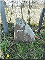
Guidestone, by the B3124, Clapton Lane, Portishead
Carved stone guidepost on the B3124, Portishead and North Weston (Avon & North Somerset District); Clapton Lane at junction with Clevedon Road, on grass verge, beside chain link fence at roundabout. C18th.
The faint inscription reads:-
1733
BRISTOL
RODE
Grade II Listed. List Entry Number:1255544
https://historicengland.org.uk/listing/the-list/list-entry/1255544
Milestone Society National ID: SO_BSTT.
Image: © Milestone Society
Taken: 16 Mar 2018
0.04 miles
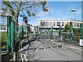
4
Construction at Gordano School
Gordano School currently undergoing major development and enlargement.
Image: © Anthony Clive Woolf
Taken: 26 Jul 2006
0.06 miles
5

Houses on Clapton Lane
A short terrace near to the junction with Maysfield Close.
Image: © Ruth Riddle
Taken: 10 Jul 2012
0.06 miles
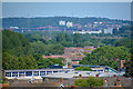
6
Portishead : Portishead Scenery
Looking down to Gordano Sixth Form.
Image: © Lewis Clarke
Taken: 2 Jun 2020
0.08 miles
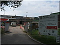
7
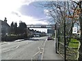
Portishead, footbridge
Across Clevedon Road (B3124), giving access to Gordano School.
Image: © Mike Faherty
Taken: 16 Mar 2018
0.08 miles
8
Portishead : Portishead Scenery
Looking out across the town of Portishead and beyond.
Image: © Lewis Clarke
Taken: 2 Jun 2020
0.09 miles
9
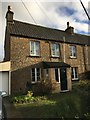
Portishead, Lipgate Place
There is a flush bracket benchmark on the frontage of No.3 Lipgate Place. See http://www.geograph.org.uk/photo/5997146 for a closer view and https://www.bench-marks.org.uk/bm18775 for details.
Image: © Brian Westlake
Taken: 3 Dec 2018
0.11 miles
10
Flush Bracket OSBM 10661: Portishead, Lipgate Place
Flush bracket benchmark on the frontage of No.3 Lipgate Place. See http://www.geograph.org.uk/photo/5997147 for a wider view and https://www.bench-marks.org.uk/bm18775 for details.
Image: © Brian Westlake
Taken: 3 Dec 2018
0.11 miles