IMAGES TAKEN NEAR TO
Dunlin Drive, BRISTOL, BS20 7NH
Introduction
This page details the photographs taken nearby to Dunlin Drive, BS20 7NH by members of the Geograph project.
The Geograph project started in 2005 with the aim of publishing, organising and preserving representative images for every square kilometre of Great Britain, Ireland and the Isle of Man.

There are currently over 7.5m images from over14,400 individuals and you can help contribute to the project by visiting https://www.geograph.org.uk
Image Map
Images are licensed for reuse under creativecommons.org/licenses/by-sa/2.0
Notes
- Clicking on the map will re-center to the selected point.
- The higher the marker number, the further away the image location is from the centre of the postcode.
Image Listing (43 Images Found)
Images are licensed for reuse under creativecommons.org/licenses/by-sa/2.0
Image
Details
Distance
1
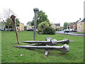
'Fallen Nails' by Cod Steaks
As part of the expansion of Portishead after the old docks closed, there were a number of public artworks dotted around. This one is a set of oversized horse nails, created by the collective of artists. The nails recall the products of the (now lost) Mustad's factory; that used to be further towards the old docks before closing in 1987 and occupied the place where Homebase and McDonald's are now.
Image: © Neil Owen
Taken: 6 May 2024
0.08 miles
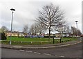
3
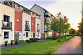
Portbury : Apartments
Apartments seen in Portishead.
Image: © Lewis Clarke
Taken: 2 Jun 2020
0.11 miles
4
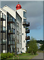
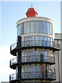
Faux lighthouse - Portishead
New housing development in Portishead that includes an apparently fake lighthouse. The position is approximate because the mapping and imaging hasn't fully caught-up.
Image: © Chris Allen
Taken: 28 Jul 2013
0.11 miles
6
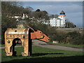
Look all about
Residents in this particular part of the new housing near Portishead Dock have a fabulous view. Sitting stop is a red finial with a ship weathervane. See Image] for a longer view of this prime property.
Image: © Neil Owen
Taken: 25 Feb 2022
0.12 miles
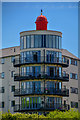
7
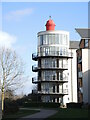
A red dome
Some of the varied residential development near Portishead Dock: one block has a larger tower at the end that has fabulous views over the Bristol Channel. It seems to have something of the apperance of a lighthouse. See Image] for a closer look at the top.
Image: © Neil Owen
Taken: 25 Feb 2022
0.12 miles
8
Modern Housing at Port Marine
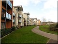
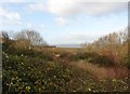
Much of the growth of Portishead's population can be attributed to the development of the former docks. The former deep-water dock used to supply coal and goods to the power stations has been fully redeveloped into a modern marina with 250 pontoon berths. The areas on each side of the marina, formerly occupied by the two power stations and chemical plant, have been redeveloped to provide a wide range of housing, from townhouses to social housing to exclusive flats.
Image: © David Dixon
Taken: 18 Jul 2021
0.13 miles
10
'Ox' by Lane Jason
In an area previously associated with some heavy industries, a heavy metal sculpture is not inappropriate. Beyond is the old Portishead dock.
Image: © Neil Owen
Taken: 25 Feb 2022
0.16 miles