IMAGES TAKEN NEAR TO
Lower Burlington Road, BRISTOL, BS20 7BP
Introduction
This page details the photographs taken nearby to Lower Burlington Road, BS20 7BP by members of the Geograph project.
The Geograph project started in 2005 with the aim of publishing, organising and preserving representative images for every square kilometre of Great Britain, Ireland and the Isle of Man.

There are currently over 7.5m images from over14,400 individuals and you can help contribute to the project by visiting https://www.geograph.org.uk
Image Map (Loading...)


Getting Data...Please wait
Leaflet Map data © OpenStreetMap
Images are licensed for reuse under creativecommons.org/licenses/by-sa/2.0
Notes
- Clicking on the map will re-center to the selected point.
- The higher the marker number, the further away the image location is from the centre of the postcode.
Image Listing (212 Images Found)
Images are licensed for reuse under creativecommons.org/licenses/by-sa/2.0
Image
Details
Distance
1
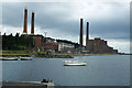
Portishead Power Station and dock
This area has been totally redeveloped. The Power Station is long gone and replaced by tall apartments overlooking the former dock which itself has been transformed into a marina.
Image: © Colin Park
Taken: 22 Aug 1981
0.03 miles
3
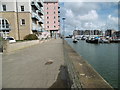
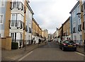
Portishead, dockside path
Along the western side of the former dock; complete with former mooring posts, and now with life-rings. http://ports.org.uk/port.asp?id=941
Image: © Mike Faherty
Taken: 16 Mar 2018
0.03 miles
4
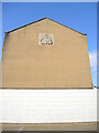
An acknowledgment on a wall
High above Watch House Street is a small stone tablet - see Image] for a closer look.
Image: © Neil Owen
Taken: 25 Feb 2022
0.04 miles
5

Marking the lifeboat trust
A stone plaque has been placed high up on an end wall, some time after the house was built. It was created by Michael Disley and recognises the contribution made by the life-savers. See Image] for the location.
Image: © Neil Owen
Taken: 25 Feb 2022
0.04 miles
6
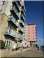
Portishead : Centre Quay
Looking towards apartments alongside the marina.
Image: © Lewis Clarke
Taken: 2 Jun 2020
0.04 miles
7
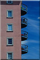
Apartment blocks, Port Marine, Portishead
Image: © Jonathan Thacker
Taken: 6 Oct 2022
0.04 miles
8
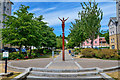
Portishead : Courtyard
Between the marina and Lower Burlington Road. Rick Kirby's statue Echo can also be seen here.
Image: © Lewis Clarke
Taken: 2 Jun 2020
0.04 miles
9
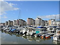
From heavy loads to leisure
Portishead Dock operated from the late 1800s to the late 1970s as an industrial facility, with a number of heavy chemical firms operating here. A coal-fired power station also went out of use about that time as the docks declined following the new Portbury Dock coming online just up the channel. With no further use, the dock was gradually converted into an up-market marina, with lots of stylish apartments surrounding it.
Image: © Neil Owen
Taken: 25 Feb 2022
0.05 miles
10

Portishead : Echo
Rick Kirby’s Echo constructed from mild steel plate. Small pieces of metal have been welded together. As mild steel it naturally oxidises in the atmosphere, its surface conjuring an array of tones in the constantly changing light.
Image: © Lewis Clarke
Taken: 2 Jun 2020
0.05 miles