IMAGES TAKEN NEAR TO
Eastcliff, BRISTOL, BS20 7AB
Introduction
This page details the photographs taken nearby to Eastcliff, BS20 7AB by members of the Geograph project.
The Geograph project started in 2005 with the aim of publishing, organising and preserving representative images for every square kilometre of Great Britain, Ireland and the Isle of Man.

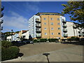
There are currently over 7.5m images from over14,400 individuals and you can help contribute to the project by visiting https://www.geograph.org.uk
Image Map (Loading...)


Getting Data...Please wait
Leaflet Map data © OpenStreetMap
Images are licensed for reuse under creativecommons.org/licenses/by-sa/2.0
Notes
- Clicking on the map will re-center to the selected point.
- The higher the marker number, the further away the image location is from the centre of the postcode.
Image Listing (285 Images Found)
Images are licensed for reuse under creativecommons.org/licenses/by-sa/2.0
Image
Details
Distance
1
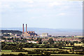
How things change over time (Portishead)
Portishead Power Station dominates this view. Two of the four chimneys had already gone and the rest of the power station would soon be demolished. The grey towers to the right of the power station were also demolished. Today, the area has been transformed into a marina with apartment blocks and the area between the houses and the estuary has also been built upon.
Image: © Colin Park
Taken: 24 Jul 1986
0.02 miles
2
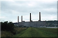
Portishead Power Station from sea wall bank
This view is unrecognisable today. The Power Station has long gone and to the left of this photograph are now high rise dwellings.
Image: © Colin Park
Taken: 22 Aug 1981
0.03 miles
3
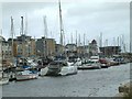
Portishead Docks and Harbourside housing
The houses are built on the old Portishead Power Station site
Image: © Ian Knox
Taken: 9 Jul 2006
0.04 miles
4
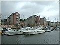
Portishead Docks and Harbourside housing
The houses are built on the old Portishead Power Station site
Image: © Ian Knox
Taken: 9 Jul 2006
0.05 miles
5
Housing, Lockside, Port Marine, Portishead
Image: © Jonathan Thacker
Taken: 6 Oct 2022
0.06 miles
6
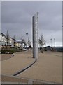
Energy Artwork
Mark Merer's Energy Artwork is an eight-metre high stainless steel sculpture that really comes into its own at night. "Coloured light of changing hue appears to emerge from below ground, energising the tower before spilling upwards into the sky from the wave-like cut outs" http://www.publicartportishead.co.uk/simple.cfm?CFID=8088915&CFTOKEN=28685906&y=y&page_id=109 . The piece stands close to the lock at the entrance to Portishead Marina.
Image: © Derek Harper
Taken: 1 Apr 2010
0.06 miles
7
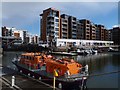
Mary Irene Millar
Lifeboat the Mary Irene Millar moored alongside the jetty just in front of the inner lock gates opposite the Marina offices.
Image: © Steve Houldsworth
Taken: 4 Mar 2016
0.06 miles
9
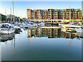
Apartments at Portishead Marina
Portishead is a coastal town on the Severn Estuary, 6 miles to the west of Bristol. Portishead had a population of 22,000 in 2016, an increase of over 3,000 since the figure of 17,130 recorded in the 2001 census https://bit.ly/3x1RsMy. A further 8,000 people are expected to settle in the area by 2026, making Portishead one of the largest towns in North Somerset.
Much of the growth of Portishead's population can be attributed to the development of the former docks. The former deep-water dock used to supply coal and goods to the power stations has been fully redeveloped into a modern marina with 250 pontoon berths. The areas on each side of the marina, formerly occupied by the two power stations and chemical plant, have been redeveloped to provide a wide range of housing, from townhouses to social housing to exclusive flats.
Image: © David Dixon
Taken: 18 Jul 2021
0.07 miles
10
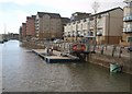
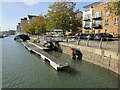
Fuel pontoon, Portishead Marina
The refuelling point is on Lockside. Beside the marina is a large development of apartments.
Image: © Derek Harper
Taken: 1 Apr 2010
0.07 miles