IMAGES TAKEN NEAR TO
Hollis Avenue, BRISTOL, BS20 6TQ
Introduction
This page details the photographs taken nearby to Hollis Avenue, BS20 6TQ by members of the Geograph project.
The Geograph project started in 2005 with the aim of publishing, organising and preserving representative images for every square kilometre of Great Britain, Ireland and the Isle of Man.

There are currently over 7.5m images from over14,400 individuals and you can help contribute to the project by visiting https://www.geograph.org.uk
Image Map (Loading...)


Getting Data...Please wait
Leaflet Map data © OpenStreetMap
Images are licensed for reuse under creativecommons.org/licenses/by-sa/2.0
Notes
- Clicking on the map will re-center to the selected point.
- The higher the marker number, the further away the image location is from the centre of the postcode.
Image Listing (34 Images Found)
Images are licensed for reuse under creativecommons.org/licenses/by-sa/2.0
Image
Details
Distance
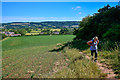
1
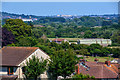
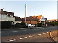
Portishead : Portishead Scenery
Looking out across the suburbs of Portishead.
Image: © Lewis Clarke
Taken: 2 Jun 2020
0.02 miles
2
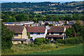
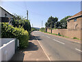
Portishead : Portishead Scenery
Looking across the outskirts of Portishead.
Image: © Lewis Clarke
Taken: 2 Jun 2020
0.05 miles
8
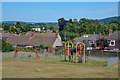
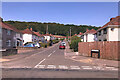
Portishead : Play Area
A play area in Portishead.
Image: © Lewis Clarke
Taken: 2 Jun 2020
0.09 miles
9
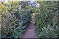
Portishead : Footpath
A footpath heads from one field to the next.
Image: © Lewis Clarke
Taken: 2 Jun 2020
0.10 miles
10
Portishead : Grassy Field
The right of way heads through the field.
Image: © Lewis Clarke
Taken: 2 Jun 2020
0.10 miles