IMAGES TAKEN NEAR TO
Oak Drive, BRISTOL, BS20 6SS
Introduction
This page details the photographs taken nearby to Oak Drive, BS20 6SS by members of the Geograph project.
The Geograph project started in 2005 with the aim of publishing, organising and preserving representative images for every square kilometre of Great Britain, Ireland and the Isle of Man.

There are currently over 7.5m images from over14,400 individuals and you can help contribute to the project by visiting https://www.geograph.org.uk
Image Map (Loading...)


Getting Data...Please wait
Leaflet Map data © OpenStreetMap
Images are licensed for reuse under creativecommons.org/licenses/by-sa/2.0
Notes
- Clicking on the map will re-center to the selected point.
- The higher the marker number, the further away the image location is from the centre of the postcode.
Image Listing (13 Images Found)
Images are licensed for reuse under creativecommons.org/licenses/by-sa/2.0
Image
Details
Distance
1
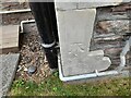
Ordnance Survey Cut Mark
This OS cut mark can be found on No58 Lower Down Road. It marks a point 77.242m above mean sea level.
Image: © Adrian Dust
Taken: 20 Aug 2022
0.11 miles
2
Ordnance Survey Cut Mark
This OS cut mark can be found on No12 Lower Down Road. It marks a point 94.741m above mean sea level.
Image: © Adrian Dust
Taken: 20 Aug 2022
0.16 miles
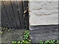
3

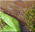
Ordnance Survey Cut Mark
This OS cut mark can be found on the retaining wall at the top of Newlands Road.
Image: © Adrian Dust
Taken: 20 Aug 2022
0.16 miles
4
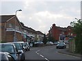
Shops, Triangle
A hilly street in Portishead.
Image: © Richard Webb
Taken: 18 Apr 2011
0.19 miles
5

Portishead : Footpath
A footpath heads across the hill.
Image: © Lewis Clarke
Taken: 2 Jun 2020
0.21 miles
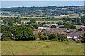
6
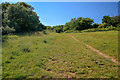
Portishead : Grassy Field
The right of way heads up the hillside.
Image: © Lewis Clarke
Taken: 2 Jun 2020
0.21 miles
7
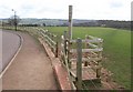
Gate onto Portishead Down
A new gate and ramp from The Downs onto Image The public footpath keeps to the right towards Big Wood and enters a rather muddy field.
Image: © Derek Harper
Taken: 1 Apr 2010
0.22 miles
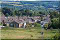
8
Portishead : Grassy Field
Looking across a grassy field.
Image: © Lewis Clarke
Taken: 2 Jun 2020
0.22 miles
9
Ordnance Survey Cut Mark
This OS cut mark can be found on the roadside building at Capenore Court. It marks a point 27.597m above mean sea level.
Image: © Adrian Dust
Taken: 14 Mar 2022
0.24 miles
10
Portishead : Grassy Field
Looking across a grassy field above Portishead.
Image: © Lewis Clarke
Taken: 2 Jun 2020
0.25 miles