IMAGES TAKEN NEAR TO
Mead Road, BRISTOL, BS20 6RZ
Introduction
This page details the photographs taken nearby to Mead Road, BS20 6RZ by members of the Geograph project.
The Geograph project started in 2005 with the aim of publishing, organising and preserving representative images for every square kilometre of Great Britain, Ireland and the Isle of Man.

There are currently over 7.5m images from over14,400 individuals and you can help contribute to the project by visiting https://www.geograph.org.uk
Image Map (17 Images)


Getting Data...Please wait
Leaflet Map data © OpenStreetMap
Images are licensed for reuse under creativecommons.org/licenses/by-sa/2.0
Notes
- Clicking on the map will re-center to the selected point.
- The higher the marker number, the further away the image location is from the centre of the postcode.
Image Listing (17 Images Found)
Images are licensed for reuse under creativecommons.org/licenses/by-sa/2.0
Image
Details
Distance
1
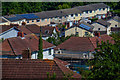
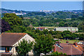
Portishead : Portishead Scenery
Looking towards rooftops on the outskirts of Portishead.
Image: © Lewis Clarke
Taken: 2 Jun 2020
0.05 miles
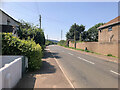
9
Portishead : Portishead Scenery
Looking out across the suburbs of Portishead.
Image: © Lewis Clarke
Taken: 2 Jun 2020
0.19 miles
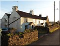
10
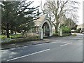
Portishead, gateway
On Clevedon Road, the entrance to Portishead Cemetery; the lodge is listed by Historic England (Grade II): http://www.imagesofengland.org.uk/Details/Default.aspx?id=459873&mode=adv
Image: © Mike Faherty
Taken: 16 Mar 2018
0.20 miles