IMAGES TAKEN NEAR TO
Drakes Way, BRISTOL, BS20 6LB
Introduction
This page details the photographs taken nearby to Drakes Way, BS20 6LB by members of the Geograph project.
The Geograph project started in 2005 with the aim of publishing, organising and preserving representative images for every square kilometre of Great Britain, Ireland and the Isle of Man.

There are currently over 7.5m images from over14,400 individuals and you can help contribute to the project by visiting https://www.geograph.org.uk
Image Map
Images are licensed for reuse under creativecommons.org/licenses/by-sa/2.0
Notes
- Clicking on the map will re-center to the selected point.
- The higher the marker number, the further away the image location is from the centre of the postcode.
Image Listing (35 Images Found)
Images are licensed for reuse under creativecommons.org/licenses/by-sa/2.0
Image
Details
Distance
1
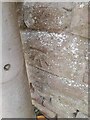
Ordnance Survey Cut Mark
This OS cut mark can be found on the wall of No93 Nore Road. It marks a point 42.767m above mean sea level.
Image: © Adrian Dust
Taken: 20 Aug 2022
0.11 miles
2
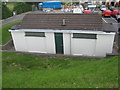
Public conveniences
Increasingly rare, and well maintained- but are they open?
Image: © Dr Duncan Pepper
Taken: 19 Jun 2009
0.13 miles
3
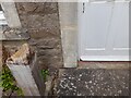
Ordnance Survey Cut Mark
This OS cut mark can be found on No52 West Hill. It marks a point 92.742m above mean sea level.
Image: © Adrian Dust
Taken: 20 Aug 2022
0.14 miles
4
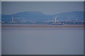
Portishead : Bristol Channel
Looking out across the Bristol Channel to the Welsh coastline. The Severn Power Station at Newport can be seen on the left of the photo and several wind turbines.
Image: © Lewis Clarke
Taken: 2 Jun 2020
0.14 miles
5
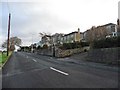
Houses with a coastal view on Nore Road
Image: © Roger Cornfoot
Taken: 9 Dec 2019
0.15 miles
6
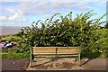
Who put that bush there?
Sit here and admire the view of the Second Severn Bridge.
Image: © Steve Daniels
Taken: 18 Aug 2010
0.16 miles
7
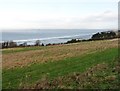
Former? golf course, West Hill
Certainly looks a bit rough in winter 2019.
Image: © Roger Cornfoot
Taken: 9 Dec 2019
0.16 miles
8
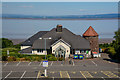
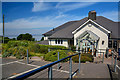
Portishead : The Windmill Inn
The Windmill Pub and Restaurant in Portishead and the Bristol Channel beyond. The car park is empty, and nobody is visiting due to coronavirus.
Image: © Lewis Clarke
Taken: 2 Jun 2020
0.16 miles
9
Portishead : The Windmill Inn
Looking towards the Windmill Inn and restaurant.
Image: © Lewis Clarke
Taken: 2 Jun 2020
0.16 miles
10
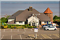
Portishead, Windmill Inn
Pub/restaurant on the side of the cliff, overlooking the Bristol Channel.
Image: © David Dixon
Taken: 21 Jul 2021
0.17 miles