IMAGES TAKEN NEAR TO
Combe Avenue, BRISTOL, BS20 6JX
Introduction
This page details the photographs taken nearby to Combe Avenue, BS20 6JX by members of the Geograph project.
The Geograph project started in 2005 with the aim of publishing, organising and preserving representative images for every square kilometre of Great Britain, Ireland and the Isle of Man.

There are currently over 7.5m images from over14,400 individuals and you can help contribute to the project by visiting https://www.geograph.org.uk
Image Map (Loading...)


Getting Data...Please wait
Leaflet Map data © OpenStreetMap
Images are licensed for reuse under creativecommons.org/licenses/by-sa/2.0
Notes
- Clicking on the map will re-center to the selected point.
- The higher the marker number, the further away the image location is from the centre of the postcode.
Image Listing (81 Images Found)
Images are licensed for reuse under creativecommons.org/licenses/by-sa/2.0
Image
Details
Distance
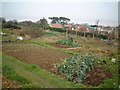
1
Portishead House
An imposing house off Nore Road; C19, once home to a Bristol wine merchant; now apartments. Listed by Historic England (Grade II): http://www.imagesofengland.org.uk/Details/Default.aspx?id=394053&mode=quick
Image: © Mike Faherty
Taken: 16 Mar 2018
0.04 miles
2
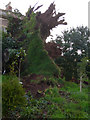
Storm Tree Fallen
Nore Gardens Portishead Saturday January
Tree fallen east of 31 Nore Road at west
7 metres plus length. 1 metre plus trunk in mistletoe, over 1.5 metre root but shallow on O.R.S. sand marl soils, brown earth, above cutting on steep slope with Atlantic wind and Beach Hill at west and Lake Grounds at North.
Image: © MDS
Taken: 20 Jan 2007
0.04 miles
3
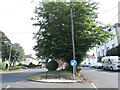
A seat on a tarmac island
West Hill: a fine view over the town from the public seat, but set in a road on all sides. See Image] for the fine view.
Image: © Neil Owen
Taken: 6 Jul 2023
0.06 miles
4
A seat on West Hill
Oddly enough, the road at West Hill at the junction with Combe Avenue has a small 'island' at the top of the hill. There's room for a couple of trees and a public seat. Just make sure you don't get run over getting there. Take Image] for a look.
Image: © Neil Owen
Taken: 6 Jul 2023
0.06 miles
5
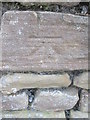
Ordnance Survey Cut Mark
This OS cut mark can be found on the south side of Nore Road. It marks a point 40.563m above mean sea level.
Image: © Adrian Dust
Taken: 17 Mar 2016
0.08 miles
6
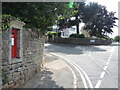
Victorian box on Nore Road
Set into the wall, a W. T. Allen product and lasting well, considering its maritime location. See Image] for a wider view.
Image: © Neil Owen
Taken: 6 Jul 2023
0.08 miles
7
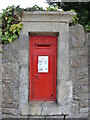
Posting on Nore Road
A Victorian letterbox - see Image] for a closer look.
Image: © Neil Owen
Taken: 6 Jul 2023
0.08 miles
8
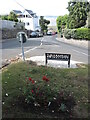
Flowers and seats overlooking the Lake Grounds
At the foot of West Hill is a little oddity: the road forms a small triangular island, descending down Beach Hill. Not wishing to waste such a valuable space, the local authorities have set planters and seats for the greater good.
Image: © Neil Owen
Taken: 6 Jul 2023
0.08 miles
9
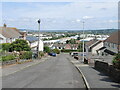
Combe Avenue
Looking down over Portishead's main road and industrial parks.
Image: © Neil Owen
Taken: 6 Jul 2023
0.09 miles