IMAGES TAKEN NEAR TO
Avon Way, BRISTOL, BS20 6JQ
Introduction
This page details the photographs taken nearby to Avon Way, BS20 6JQ by members of the Geograph project.
The Geograph project started in 2005 with the aim of publishing, organising and preserving representative images for every square kilometre of Great Britain, Ireland and the Isle of Man.

There are currently over 7.5m images from over14,400 individuals and you can help contribute to the project by visiting https://www.geograph.org.uk
Image Map (Loading...)


Getting Data...Please wait
Leaflet Map data © OpenStreetMap
Images are licensed for reuse under creativecommons.org/licenses/by-sa/2.0
Notes
- Clicking on the map will re-center to the selected point.
- The higher the marker number, the further away the image location is from the centre of the postcode.
Image Listing (33 Images Found)
Images are licensed for reuse under creativecommons.org/licenses/by-sa/2.0
Image
Details
Distance
1
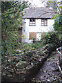
Stoney Steep Cottage
In the pit of Avon Way garage plot, at the stream and opposite the old goat yard of William Harry Stagg stands some young person's dream of renovation for a small Kevin McCloud style home with all the features of a Grand Design, including only a footpath access, impossible construction traffic approach, steep main road to the south, conservation valley and steep, steep path to the north and an old well to the south. You need good feet on the cobble and slab, preferably not in winter cold, although I know eldery ladies who tramped this as home for years when the upslope was all Combe Fields, to the stream lined with large trees to Combe Road gate.
Image: © MDS
Taken: 25 Nov 2006
0.02 miles
2
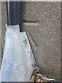
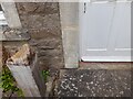
Ordnance Survey Cut Mark
This OS cut mark can be found on the front of No33 West Hill. It marks a point 61.195m above mean sea level.
Image: © Adrian Dust
Taken: 17 Mar 2016
0.11 miles
3
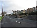
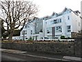
Houses with a coastal view on Nore Road
Image: © Roger Cornfoot
Taken: 9 Dec 2019
0.17 miles
4
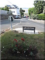
A seat on West Hill
Oddly enough, the road at West Hill at the junction with Combe Avenue has a small 'island' at the top of the hill. There's room for a couple of trees and a public seat. Just make sure you don't get run over getting there. Take Image] for a look.
Image: © Neil Owen
Taken: 6 Jul 2023
0.17 miles
5
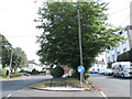
A seat on a tarmac island
West Hill: a fine view over the town from the public seat, but set in a road on all sides. See Image] for the fine view.
Image: © Neil Owen
Taken: 6 Jul 2023
0.17 miles
7
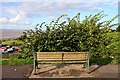
Who put that bush there?
Sit here and admire the view of the Second Severn Bridge.
Image: © Steve Daniels
Taken: 18 Aug 2010
0.19 miles
8
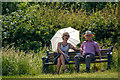
Portishead : Kilkenny Fields
A couple sat in the sunshine at Kilkenny Fields.
Image: © Lewis Clarke
Taken: 2 Jun 2020
0.20 miles
9
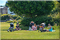
Portishead : Kilkenny Fields
People enjoying the sunshine at Kilkenny Fields.
Image: © Lewis Clarke
Taken: 2 Jun 2020
0.21 miles
10
Ordnance Survey Cut Mark
This OS cut mark can be found on No52 West Hill. It marks a point 92.742m above mean sea level.
Image: © Adrian Dust
Taken: 20 Aug 2022
0.21 miles