IMAGES TAKEN NEAR TO
Down Road, BRISTOL, BS20 6DY
Introduction
This page details the photographs taken nearby to Down Road, BS20 6DY by members of the Geograph project.
The Geograph project started in 2005 with the aim of publishing, organising and preserving representative images for every square kilometre of Great Britain, Ireland and the Isle of Man.

There are currently over 7.5m images from over14,400 individuals and you can help contribute to the project by visiting https://www.geograph.org.uk
Image Map (Loading...)


Getting Data...Please wait
Leaflet Map data © OpenStreetMap
Images are licensed for reuse under creativecommons.org/licenses/by-sa/2.0
Notes
- Clicking on the map will re-center to the selected point.
- The higher the marker number, the further away the image location is from the centre of the postcode.
Image Listing (15 Images Found)
Images are licensed for reuse under creativecommons.org/licenses/by-sa/2.0
Image
Details
Distance
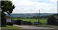
1
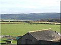
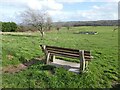
High View
Hilltop housing estate in Portishead.
Image: © Richard Webb
Taken: 18 Apr 2011
0.09 miles
3
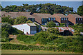
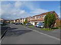
Portishead : Houses
Houses seen from Portishead Down.
Image: © Lewis Clarke
Taken: 2 Jun 2020
0.11 miles
4
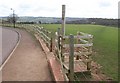
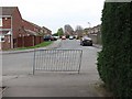
Gate onto Portishead Down
A new gate and ramp from The Downs onto Image The public footpath keeps to the right towards Big Wood and enters a rather muddy field.
Image: © Derek Harper
Taken: 1 Apr 2010
0.16 miles
5
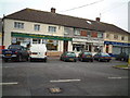
Shops at Triangle
Shops at the triangle West Hill
Image: © Adrian and Janet Quantock
Taken: 4 Feb 2006
0.17 miles
10
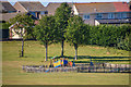
Portishead : Merlin Park Playground
Looking to a play area in Merlin Park.
Image: © Lewis Clarke
Taken: 2 Jun 2020
0.21 miles