IMAGES TAKEN NEAR TO
Halletts Way, BRISTOL, BS20 6BT
Introduction
This page details the photographs taken nearby to Halletts Way, BS20 6BT by members of the Geograph project.
The Geograph project started in 2005 with the aim of publishing, organising and preserving representative images for every square kilometre of Great Britain, Ireland and the Isle of Man.

There are currently over 7.5m images from over14,400 individuals and you can help contribute to the project by visiting https://www.geograph.org.uk
Image Map (Loading...)


Getting Data...Please wait
Leaflet Map data © OpenStreetMap
Images are licensed for reuse under creativecommons.org/licenses/by-sa/2.0
Notes
- Clicking on the map will re-center to the selected point.
- The higher the marker number, the further away the image location is from the centre of the postcode.
Image Listing (86 Images Found)
Images are licensed for reuse under creativecommons.org/licenses/by-sa/2.0
Image
Details
Distance

3

Folk Hall, Portishead
The hall has a room that will hold up to 100 people, with a kitchen and bar facilities.
Image: © Neil Owen
Taken: 26 Oct 2022
0.12 miles

6
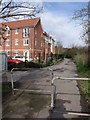
Footpath in Portishead
The public footpath links Forester Road with the High Street. The block of flats on the left is St Peter's Lodge.
Image: © Derek Harper
Taken: 1 Apr 2010
0.13 miles
7
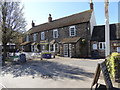
Poacher - Portishead
Heavily into food but pleasant to visit.
Image: © Steve Barnes
Taken: 6 Apr 2015
0.14 miles
8
Bear Reeds
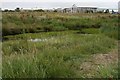
It used to be The Bear pond, now it is advertised by Lenny Henry, but the point is still the same, the estate flood attenuation and hotel restaurant discharge pond is now finally an ecologically decorative landscape as the reeds have grown with the assistance of some dedicated people. The map shows a reach now under culvert and soil which is a shame, but then drowning people's very active children that climb fences at lunchtime is not to be advised for restaurants seeking business, so one can understand the removal from alongside the garden. Pity about the delayed weed development also shown, but soon we may be rid of that too, I thought government and local authority wanted trade (Arthur Llewellyn Jenkins, we had to go to Cribbs Causeway to replace a collapsed sofa, her brother went to a good part of the West Country for a care relative, very good sofa, but we would have preferred to buy locally as we did our other furniture and half an antique or two) and they like development to increase the Rateable income, especially of old sites re-used under central funding rules, however relief of planning regulations has just destroyed design, saturated places with housing with no work base, congested, flooded streets, on waste tips and left us with many offices that are empty and rented by government to keep up the appearance; the Council has fought this left right and centre and we begin to see progress as poor plans are vetoed, good ones passed and the general junk attitude of British society (a note made by my Geology teacher at School during the 1960s) is overcome. Little by little these sorts of projects are winning, so thugs can throw glass and rocks at ducks and fill the place with plastic waste, alike About a Boy (film with Hugh Grant) a point about a new form of duck shooting, in old marshlands, but we are gradually winning as this shows. Thank you Aidan Millerick.
Image: © Michael Dennis Stagg
Taken: 25 Jun 2011
0.15 miles
9

Court House Farm and church, Portishead
See Image; the top of the hexagonal tower of the farmhouse peeps above outbuildings. The C19 farm buildings on the left are listed http://www.imagesofengland.org.uk/details/default.aspx?id=394006 .
Image: © Derek Harper
Taken: 1 Apr 2010
0.15 miles
10
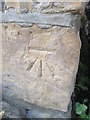
Ordnance Survey Cut Mark
This OS cut mark can be found on No3 Victoria Square. It marks a point 7.708m above mean sea level.
Image: © Adrian Dust
Taken: 17 Mar 2016
0.16 miles