IMAGES TAKEN NEAR TO
Slade Road, BRISTOL, BS20 6AP
Introduction
This page details the photographs taken nearby to Slade Road, BS20 6AP by members of the Geograph project.
The Geograph project started in 2005 with the aim of publishing, organising and preserving representative images for every square kilometre of Great Britain, Ireland and the Isle of Man.

There are currently over 7.5m images from over14,400 individuals and you can help contribute to the project by visiting https://www.geograph.org.uk
Image Map (Loading...)


Getting Data...Please wait
Leaflet Map data © OpenStreetMap
Images are licensed for reuse under creativecommons.org/licenses/by-sa/2.0
Notes
- Clicking on the map will re-center to the selected point.
- The higher the marker number, the further away the image location is from the centre of the postcode.
Image Listing (85 Images Found)
Images are licensed for reuse under creativecommons.org/licenses/by-sa/2.0
Image
Details
Distance
1

Early morning light & mist as seen from Adlington House, Portishead
Image: © Colin Park
Taken: 24 Oct 2018
0.03 miles
3
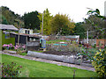
Classic 1950s Garden
Slade, but not the Music Group, 1950s garden in the 2006 era, if you turn up the path from this road, below the horse paddock soot enriched mounded soils dusted with fertilizer and one's own air raid shelter in brick in front of the greenhouse.
Image: © MDS
Taken: 12 Nov 2006
0.05 miles
4

Evening shower clouds passing S of Bath as seen from Slade Rd, Portishead
Image: © Colin Park
Taken: 5 Nov 2017
0.06 miles
6
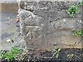
Ordnance Survey Cut Mark
This OS cut mark can be found on the wall south side of Newlands Hill. It marks a point 23.281m above mean sea level.
Image: © Adrian Dust
Taken: 14 Mar 2022
0.08 miles
7
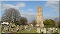
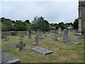
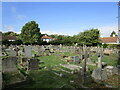
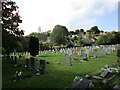
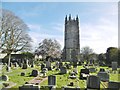
St Peter's graveyard
The church is dated from about 1320 and may well be the oldest building in Portishead. Hence, the graveyards are extensive and populated.
Image: © Neil Owen
Taken: 26 Oct 2022
0.08 miles
8
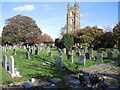
Portishead, St. Peter's
Parish church on Church Road North/South; with Norman origins, rebuilt C14, 15, 20. Listed by Historic England (Grade I): http://www.imagesofengland.org.uk/Details/Default.aspx?id=394001&mode=adv
Image: © Mike Faherty
Taken: 16 Mar 2018
0.08 miles