IMAGES TAKEN NEAR TO
Martcombe Road, BRISTOL, BS20 0QN
Introduction
This page details the photographs taken nearby to Martcombe Road, BS20 0QN by members of the Geograph project.
The Geograph project started in 2005 with the aim of publishing, organising and preserving representative images for every square kilometre of Great Britain, Ireland and the Isle of Man.

There are currently over 7.5m images from over14,400 individuals and you can help contribute to the project by visiting https://www.geograph.org.uk
Image Map (Loading...)


Getting Data...Please wait
Leaflet Map data © OpenStreetMap
Images are licensed for reuse under creativecommons.org/licenses/by-sa/2.0
Notes
- Clicking on the map will re-center to the selected point.
- The higher the marker number, the further away the image location is from the centre of the postcode.
Image Listing (12 Images Found)
Images are licensed for reuse under creativecommons.org/licenses/by-sa/2.0
Image
Details
Distance
1
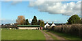
New Park Farm
Seen looking up the private drive from Happerton Lane, which is followed by the Gordano Round. A reception committee awaits on the left.
Image: © Derek Harper
Taken: 17 Mar 2022
0.07 miles
2
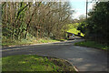
A369 at Haberfield Bridge
From the junction with Happerton Lane as the main road swoops round a bend in Markham Bottom.
Image: © Derek Harper
Taken: 17 Mar 2022
0.12 miles
3
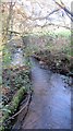
Looking downstream over the Markham Brook
Image: © Dr Duncan Pepper
Taken: 29 Dec 2015
0.13 miles
4
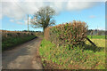
Gordano Round on Happerton Lane
Shown near New Park House.
Image: © Derek Harper
Taken: 17 Mar 2022
0.13 miles
5
Old Bridge Marker by the A369 on Haberfield Bridge
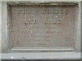
Bridge Marker set on the parapet of Haberfield Bridge, Markham Brook, on the south side of the A369 Haberfield Hill. Pill and Easton-in-Gordano parish. To the left of SO_PEIG02br. In raised lettering THIS BRIDGE / WAS ERECTED / AND ROAD / WIDENED BY / BENJAMIN FARMER / BUILDER / BRISTOL / 1850.
Milestone Society National ID: SO_PEIG01br
Image: © Roadside Relics
Taken: 15 Jun 2022
0.13 miles
6
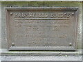
Old Bridge Marker by the A369 on Haberfield Bridge
Bridge Marker set on the parapet of Haberfield Bridge, Markham Brook, on the south side of the A369 Haberfield Hill. Pill and Easton-in-Gordano parish. To the right of SO_PEIG01br. In raised lettering HABERFIELD BRIDGE / THIS ROAD HAVING BEEN RAISED / AND WIDENED WAS REOPENED THE / 9th DECEMBER 1850 / BY / JOHN KERLE HABERFIELD ESQre, / SIXTH TIME / MAYOR OF BRISTOL.
Milestone Society National ID: SO_PEIG02br
Image: © Roadside Relics
Taken: 15 Jun 2022
0.13 miles
7
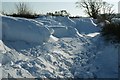
Snowdrifts, Happerton Lane, Lower Failand
Image: © Colin Park
Taken: 11 Jan 1982
0.15 miles
8

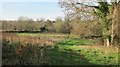
Pill and Easton-in-Gordano : Grassy Field
Looking along a grassy field.
Image: © Lewis Clarke
Taken: 26 Jun 2020
0.20 miles
9
Disused farmland between Haberfield Park Farm and the Markham Brook
Image: © Dr Duncan Pepper
Taken: 29 Dec 2015
0.20 miles
10
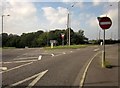
Junction on the A369
Pill Road turns off the main road at the top of Haberfield Hill.
Image: © Derek Harper
Taken: 30 Sep 2014
0.21 miles