IMAGES TAKEN NEAR TO
Beechwood Road, BRISTOL, BS20 0NA
Introduction
This page details the photographs taken nearby to Beechwood Road, BS20 0NA by members of the Geograph project.
The Geograph project started in 2005 with the aim of publishing, organising and preserving representative images for every square kilometre of Great Britain, Ireland and the Isle of Man.

There are currently over 7.5m images from over14,400 individuals and you can help contribute to the project by visiting https://www.geograph.org.uk
Image Map (Loading...)


Getting Data...Please wait
Leaflet Map data © OpenStreetMap
Images are licensed for reuse under creativecommons.org/licenses/by-sa/2.0
Notes
- Clicking on the map will re-center to the selected point.
- The higher the marker number, the further away the image location is from the centre of the postcode.
Image Listing (59 Images Found)
Images are licensed for reuse under creativecommons.org/licenses/by-sa/2.0
Image
Details
Distance
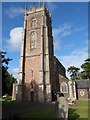
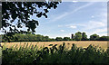
1
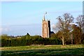
Easton in Gordano Church
View east towards the church from the fields in between the village and the Motorway Services.
Image: © Nigel Mykura
Taken: 11 Apr 2009
0.04 miles
2
St George, Easton in Gordano: churchyard (c)
Image: © Basher Eyre
Taken: 24 Jun 2017
0.06 miles
3
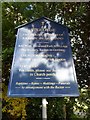
St George, Easton in Gordano: notice board
Image: © Basher Eyre
Taken: 24 Jun 2017
0.06 miles
4
St George, Easton in Gordano: churchyard (b)
Image: © Basher Eyre
Taken: 24 Jun 2017
0.06 miles
6
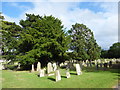
St George, Easton in Gordano: churchyard (a)
Image: © Basher Eyre
Taken: 24 Jun 2017
0.06 miles
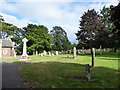
7
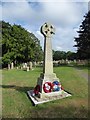
St George, Easton in Gordano: war memorial
Image: © Basher Eyre
Taken: 24 Jun 2017
0.06 miles
8
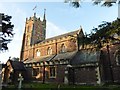
Church of St George, Easton in Gordano
Image: © Roger Cornfoot
Taken: 18 Nov 2019
0.07 miles
9
The tower of Easton-in-Gordano church seen from M5 Gordano Services
A high landscaped bank crowned by woodland is the visual boundary of the Gordano Services car park. A stroll into the wood and down the back slope of the bank (deliciously cool and quiet on a very busy, very warm day) is rewarded by this view to the handsome church of St George in the village.
Image: © Robin Stott
Taken: 25 Jul 2018
0.07 miles
10
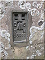
Ordnance Survey Flush Bracket (S8911) & 1GL Bolt
This OS Flush Bracket can be found on the west face of St George's Church. It marks a point 15.075m above mean sea level. The bolt lost its arrow when the FB was installed.
Image: © Adrian Dust
Taken: 15 May 2015
0.07 miles