IMAGES TAKEN NEAR TO
Lodway, BRISTOL, BS20 0JD
Introduction
This page details the photographs taken nearby to Lodway, BS20 0JD by members of the Geograph project.
The Geograph project started in 2005 with the aim of publishing, organising and preserving representative images for every square kilometre of Great Britain, Ireland and the Isle of Man.

There are currently over 7.5m images from over14,400 individuals and you can help contribute to the project by visiting https://www.geograph.org.uk
Image Map (Loading...)


Getting Data...Please wait
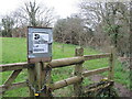
Leaflet Map data © OpenStreetMap
Images are licensed for reuse under creativecommons.org/licenses/by-sa/2.0
Notes
- Clicking on the map will re-center to the selected point.
- The higher the marker number, the further away the image location is from the centre of the postcode.
Image Listing (23 Images Found)
Images are licensed for reuse under creativecommons.org/licenses/by-sa/2.0
Image
Details
Distance
1
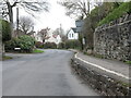
A ledge along Lodway
The road had a raised pavement bounding one side, but a narrow one at that. Two people meeting on it will need to squeeze past each other or risk a drop to the tarmac.
Image: © Neil Owen
Taken: 22 Mar 2023
0.01 miles
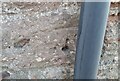
2
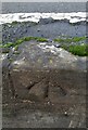
Ordnance Survey Rivet
This OS rivet can be found on the retaining wall north side of Lodway. It marks a point 19.900m above mean sea level.
Image: © Adrian Dust
Taken: 1 Nov 2021
0.03 miles
3
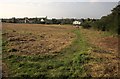
Field, Easton-in-Gordano
Crossed by footpaths; this one is LA8 11/10, leading to Old Priory Road.
Image: © Derek Harper
Taken: 30 Sep 2014
0.14 miles
4
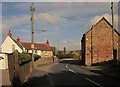
Priory Road, Easton-in-Gordano
The road winds between cottages.
Image: © Derek Harper
Taken: 30 Sep 2014
0.15 miles
5
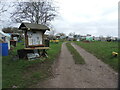
Pill allotments
Plenty of gardening access on Crosslanes. The noticeboard appears to have all sorts of community announcements, not just agricultural.
Image: © Neil Owen
Taken: 22 Mar 2023
0.16 miles
6
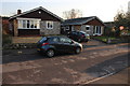
Bungalows in Lodway
These bungalows are on the South side of the Breaches which is in the very north west corner of Pill and in the south east corner of the grid square.
Image: © Nigel Mykura
Taken: 20 Jan 2017
0.16 miles
7
Ordnance Survey Cut Mark
This OS cut mark can be found on No3 Priory Road. It marks a point 16.954m above mean sea level.
Image: © Adrian Dust
Taken: 1 Nov 2021
0.16 miles
8
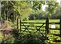
Gate into Pill Paddock
"The local community has transformed this old allotment site into a nature reserve, now home to a range of birds and butterflies." http://www.wildlifetrusts.org/reserves/pill-paddock . This is passed by footpath LA8/12/40.
Image: © Derek Harper
Taken: 30 Sep 2014
0.18 miles
9
Pill Paddock Nature Reserve
A small pocket of open space in a small strip of woodland is offically a nature reserve.
Image: © Neil Owen
Taken: 22 Mar 2023
0.19 miles
10
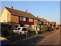
Houses in Lodway
These semi detached houses which appear to date for the 1970's or 80's ar on the north side of the Breaches and their back gardens back on to fields adjacent to the M5 between Junction 19 and the River Avon.
Image: © Nigel Mykura
Taken: 20 Jan 2017
0.19 miles