IMAGES TAKEN NEAR TO
Applehayes Rise, BRISTOL, BS20 0FD
Introduction
This page details the photographs taken nearby to Applehayes Rise, BS20 0FD by members of the Geograph project.
The Geograph project started in 2005 with the aim of publishing, organising and preserving representative images for every square kilometre of Great Britain, Ireland and the Isle of Man.

There are currently over 7.5m images from over14,400 individuals and you can help contribute to the project by visiting https://www.geograph.org.uk
Image Map (Loading...)


Getting Data...Please wait
Leaflet Map data © OpenStreetMap
Images are licensed for reuse under creativecommons.org/licenses/by-sa/2.0
Notes
- Clicking on the map will re-center to the selected point.
- The higher the marker number, the further away the image location is from the centre of the postcode.
Image Listing (21 Images Found)
Images are licensed for reuse under creativecommons.org/licenses/by-sa/2.0
Image
Details
Distance
1
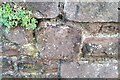
Ordnance Survey Cut Mark
This OS cut mark can be found on the wall of Hillview. It marks a point 28.118m above mean sea level.
Image: © Adrian Dust
Taken: 1 Nov 2021
0.04 miles
3
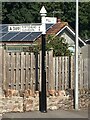
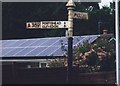
Restored Finger Post at Easton-in-Gordano
Looking splendid after a restoration and repaint is this fingerpost that stands on the former A369 in Easton-in-Gordano. The village is now bypassed. The remains of a third arm, which can be seen at https://www.geograph.org.uk/photo/6042439, and presumably indicated 6.5 miles to Bristol, have been removed.
Milestone Society National ID: SO_ST5175
Image: © Brian Westlake
Taken: 7 Aug 2020
0.05 miles
4
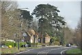
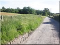
North Somerset : Martcombe Road
Martcombe Road heading towards Bristol from the M5 Motorway.
Image: © Lewis Clarke
Taken: 1 Feb 2013
0.05 miles
5
Old Direction Sign - Signpost by the former A369, St George's Hill, Easton in Gordano Parish
Pyramid finial - 3 arms, 1 broken off; Somerset SCC pyramid by the UC road (was A369), in parish of Easton in Gordano (North Somerset District), crossroads of Priory Road with St George's Hill.
Surveyed
Milestone Society National ID: SO_ST5175
Image: © E Prideaux
Taken: Unknown
0.05 miles
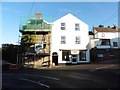
7
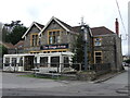
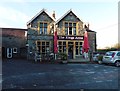
The Kings Arms, Easton-in-Gordano
An old pub on the crossroads, which appears to still have some sort of Christmas tree in the yard.
Image: © Neil Owen
Taken: 22 Mar 2023
0.11 miles
9
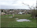
Wet on top
The raised land between Easton-in-Gordano and Pill is rather wet still after a particularly damp March. Reached by the footpath from Parsonage Farm, which used to be called Prebendal Farm in the Victorian era.
Image: © Neil Owen
Taken: 22 Mar 2023
0.13 miles
10
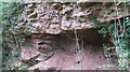
A geological unconformity in Summer House Wood
The upper layer is a Triassic Mercia Mudstone whilst the lower layer is Blacknore lower Devonian sandstone-separated by 200 million years.
Image: © Dr Duncan Pepper
Taken: 17 Nov 2016
0.13 miles