IMAGES TAKEN NEAR TO
The Moorings, BRISTOL, BS20 0EG
Introduction
This page details the photographs taken nearby to The Moorings, BS20 0EG by members of the Geograph project.
The Geograph project started in 2005 with the aim of publishing, organising and preserving representative images for every square kilometre of Great Britain, Ireland and the Isle of Man.

There are currently over 7.5m images from over14,400 individuals and you can help contribute to the project by visiting https://www.geograph.org.uk
Image Map
Images are licensed for reuse under creativecommons.org/licenses/by-sa/2.0
Notes
- Clicking on the map will re-center to the selected point.
- The higher the marker number, the further away the image location is from the centre of the postcode.
Image Listing (82 Images Found)
Images are licensed for reuse under creativecommons.org/licenses/by-sa/2.0
Image
Details
Distance
1
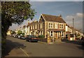
Junction, Pill
On the left is Springfield Road; on the right, Church Path Road.
Image: © Derek Harper
Taken: 30 Sep 2014
0.07 miles
2
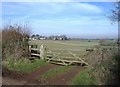
View towards the Bristol Channel
From Happerton Lane, with the edge of Pill in the middle distance.
Image: © Roger Cornfoot
Taken: 4 Feb 2007
0.09 miles
3
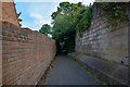
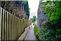
Pill : Footpath
A footpath between Water Lane and Westward Drive.
Image: © Lewis Clarke
Taken: 26 Jun 2020
0.09 miles
4
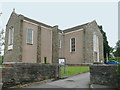
Christ Church, Pill
Pill's previous church was destroyed in an air raid in January, 1941. The Church Rooms did duty as a stop-gap, till the new Christ Church, built on the foundations of the old, was consecrated, in May, 1958.
Image: © Kerryn
Taken: 12 Jun 2012
0.09 miles
5
Pill : Footpath
A path between Westward Drive and Water Lane.
Image: © Lewis Clarke
Taken: 26 Jun 2020
0.10 miles
6
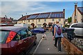
Pill : Water Lane
Looking along Water Lane in Pill.
Image: © Lewis Clarke
Taken: 26 Jun 2020
0.10 miles
7
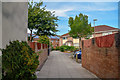
Pill : Pavement
Looking along a pavement off Water Lane.
Image: © Lewis Clarke
Taken: 26 Jun 2020
0.11 miles
8
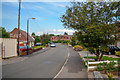
Pill : Westward Drive
Looking along a residential road in Pill.
Image: © Lewis Clarke
Taken: 26 Jun 2020
0.11 miles
9
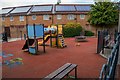
Pill : Playground
A children's play area.
Image: © Lewis Clarke
Taken: 26 Jun 2020
0.11 miles
10
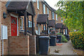
Pill : Heywood Road
Houses along Heywood Road.
Image: © Lewis Clarke
Taken: 26 Jun 2020
0.12 miles