IMAGES TAKEN NEAR TO
Easton Road, BRISTOL, BS20 0DT
Introduction
This page details the photographs taken nearby to Easton Road, BS20 0DT by members of the Geograph project.
The Geograph project started in 2005 with the aim of publishing, organising and preserving representative images for every square kilometre of Great Britain, Ireland and the Isle of Man.

There are currently over 7.5m images from over14,400 individuals and you can help contribute to the project by visiting https://www.geograph.org.uk
Image Map (Loading...)


Getting Data...Please wait
Leaflet Map data © OpenStreetMap
Images are licensed for reuse under creativecommons.org/licenses/by-sa/2.0
Notes
- Clicking on the map will re-center to the selected point.
- The higher the marker number, the further away the image location is from the centre of the postcode.
Image Listing (34 Images Found)
Images are licensed for reuse under creativecommons.org/licenses/by-sa/2.0
Image
Details
Distance
1
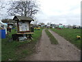
Pill allotments
Plenty of gardening access on Crosslanes. The noticeboard appears to have all sorts of community announcements, not just agricultural.
Image: © Neil Owen
Taken: 22 Mar 2023
0.07 miles
2
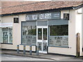
Not a place for a pint
The New Avon Arms in Pill. No, it's not a pub - it's a gun shop.
Image: © Neil Owen
Taken: 22 Mar 2023
0.11 miles
3
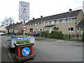
Slow in Westward Drive
A small planter provides a location not only for some flowers but also fixes a road sign or two.
Image: © Neil Owen
Taken: 22 Mar 2023
0.11 miles
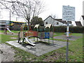
4
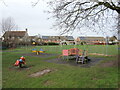
Hardwick Road play area
A site for the little ones beside the recreation ground.
Image: © Neil Owen
Taken: 22 Mar 2023
0.11 miles
5
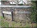
New sign in Pill
Two plates for the price of one road.
Image: © Neil Owen
Taken: 22 Mar 2023
0.11 miles
6
Not for over-twelves
The equipment is for the younger visitors, and not for dogs or smokers either.
Image: © Neil Owen
Taken: 22 Mar 2023
0.12 miles
7
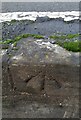
Ordnance Survey Rivet
This OS rivet can be found on the retaining wall north side of Lodway. It marks a point 19.900m above mean sea level.
Image: © Adrian Dust
Taken: 1 Nov 2021
0.13 miles
8
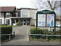
Heywood Surgery
Pill's healthcare centre on Lodway Road, along with some local announcements.
Image: © Neil Owen
Taken: 22 Mar 2023
0.13 miles
9
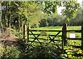
Gate into Pill Paddock
"The local community has transformed this old allotment site into a nature reserve, now home to a range of birds and butterflies." http://www.wildlifetrusts.org/reserves/pill-paddock . This is passed by footpath LA8/12/40.
Image: © Derek Harper
Taken: 30 Sep 2014
0.14 miles
10
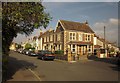
Junction, Pill
On the left is Springfield Road; on the right, Church Path Road.
Image: © Derek Harper
Taken: 30 Sep 2014
0.15 miles