IMAGES TAKEN NEAR TO
BS18 3HY
Introduction
This page details the photographs taken nearby to BS18 3HY by members of the Geograph project.
The Geograph project started in 2005 with the aim of publishing, organising and preserving representative images for every square kilometre of Great Britain, Ireland and the Isle of Man.

There are currently over 7.5m images from over14,400 individuals and you can help contribute to the project by visiting https://www.geograph.org.uk
Image Map
Images are licensed for reuse under creativecommons.org/licenses/by-sa/2.0
Notes
- Clicking on the map will re-center to the selected point.
- The higher the marker number, the further away the image location is from the centre of the postcode.
Image Listing (15 Images Found)
Images are licensed for reuse under creativecommons.org/licenses/by-sa/2.0
Image
Details
Distance
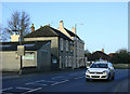
2
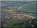
The River Avon west of Keynsham.
Looking down on to Saltford and Saltford Golf Club.
Image: © M J Richardson
Taken: 30 Dec 2014
0.15 miles
3
Double rainbow over Manor Road
Manor Road is the continuation of Beech Road south of the A4, and passes south through a newer part of Saltford towards the golf course. To judge by the location of the rainbow (an outer double rainbow is just visible), there may be a pot of gold somewhere near the railway line and perhaps a smaller one in Avon Valley Country Park.
Image: © HelenK
Taken: 27 Sep 2019
0.16 miles
4
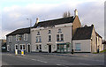
The Crown, Saltford
Situated on the main A4 between Bath and Bristol. See http://www.geograph.org.uk/photo/1696821 for more information.
Image: © Rick Crowley
Taken: 6 Mar 2010
0.18 miles
5
2010 : The Crown, Saltford
"The Crown is to be found on the A4 between Bath and Bristol in the large village / small town of Saltford. Close to the golf club, the building is one of the oldest in the area with the first licensee registered here back in 1765! There is a light and airy, fresh feel to the place with its hard wood floors, clean furnishings and pastille shades. The lounge bar has an open fire lit in the winter months and there is a separate restaurant and public bar. Quality food is served from a main menu with homemade specials available and can be eaten anywhere in the pub and al fresco during the summer. Our clientele are very varied and range from the regular locals to passers by, couples and families."
The above was copied from: http://www.pub-explorer.com/somerset/pub/crownsaltford.htm
Shouldn't that be "clientele is"?
Image: © Maurice Pullin
Taken: 5 Feb 2010
0.20 miles
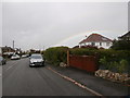
6
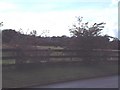
Horse paddocks and farmland viewed from Manor Road
Image: © Elizabeth Spincer
Taken: Unknown
0.20 miles
7
Claverton Rd, Saltford.
Taken during the Queen's Jubilee
Image: © Rick Crowley
Taken: 3 Jun 2012
0.21 miles
8
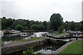
Kelston lock and weir, on the River Avon.
This stretch of the river is in the very NE corner of the grid, this picture is looking downstream (NW).
Image: © Martyn Pattison
Taken: 4 Aug 2005
0.21 miles
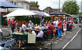
9
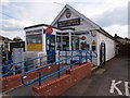
Saltford Post Office
The combined Post Office and community library after many months of negotiation is open.
It is part of Bath and North East Somerset Council’s Modern Libraries programme. A very useful asset to Saltford. Volunteers help in the library. It also has an excellent selection of cards for sale.
Image: © Rick Crowley
Taken: 29 Apr 2019
0.23 miles
10
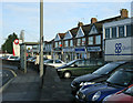
2010 : Rank of shops with Post Office, Saltford
It says something about the prosperity and nature of Saltford that it is able to support this many shops in competition with supermarkets in nearby Bath, Keynsham and Bristol. There is also a newsagent on the other side of the A4 and more shops further on.
Image: © Maurice Pullin
Taken: 5 Feb 2010
0.24 miles