IMAGES TAKEN NEAR TO
Mede Close, BRISTOL, BS1 6RN
Introduction
This page details the photographs taken nearby to Mede Close, BS1 6RN by members of the Geograph project.
The Geograph project started in 2005 with the aim of publishing, organising and preserving representative images for every square kilometre of Great Britain, Ireland and the Isle of Man.

There are currently over 7.5m images from over14,400 individuals and you can help contribute to the project by visiting https://www.geograph.org.uk
Image Map
Images are licensed for reuse under creativecommons.org/licenses/by-sa/2.0
Notes
- Clicking on the map will re-center to the selected point.
- The higher the marker number, the further away the image location is from the centre of the postcode.
Image Listing (789 Images Found)
Images are licensed for reuse under creativecommons.org/licenses/by-sa/2.0
Image
Details
Distance
1
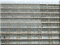
Keeping the flies out?
Spencer House is undergoing some work and is cocooned in scaffolding and netting.
Image: © Neil Owen
Taken: 4 Sep 2019
0.01 miles
4
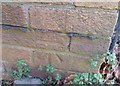
Chatterton House, Ship Lane
There is an OS benchmark Image on the near corner, road face, of the brick jut, right of the large green wheelie bin
Image: © Roger Templeman
Taken: 4 Feb 2018
0.04 miles
5
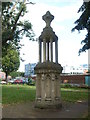
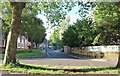
A feature in Somerset Square
This elegant work is listed as a fountain, although it clearly has not been supplied with water for some time.
Image: © Neil Owen
Taken: 4 Sep 2019
0.04 miles
6
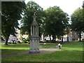
Somerset Square
Dating from 1756, it was a central point of Georgian development in Redcliffe, along with a number of fine houses that are now gone. There are a number of mature Lime trees (labelled by the local community group), some of which may be originals. See Image] for a closer look at the centre fountain.
Image: © Neil Owen
Taken: 4 Sep 2019
0.04 miles
7
Benchmark on Chatterton House, Ship Lane
Ordnance Survey cut mark benchmark described on the Bench Mark Database at http://www.bench-marks.org.uk/bm89203
Image: © Roger Templeman
Taken: 4 Feb 2018
0.05 miles
8
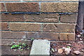
Ordnance Survey Cut Mark
This OS cut mark can be found on the west side of Ship Lane. It marks a point 12.945m above mean sea level.
Image: © Adrian Dust
Taken: 19 Jan 2020
0.05 miles
9
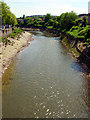
River Avon from Bedminster Bridge
Looking east, upstream, along the River Avon which is tidal here.
Image: © Linda Bailey
Taken: 5 Jun 2006
0.05 miles
10
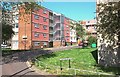
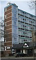
Bristol Apartments (13)
Aston House, Burton Close
Image: © Anthony O'Neil
Taken: 20 Apr 2020
0.06 miles