IMAGES TAKEN NEAR TO
Abson Road, BRISTOL, BS16 9SA
Introduction
This page details the photographs taken nearby to Abson Road, BS16 9SA by members of the Geograph project.
The Geograph project started in 2005 with the aim of publishing, organising and preserving representative images for every square kilometre of Great Britain, Ireland and the Isle of Man.

There are currently over 7.5m images from over14,400 individuals and you can help contribute to the project by visiting https://www.geograph.org.uk
Image Map (Loading...)


Getting Data...Please wait
Leaflet Map data © OpenStreetMap
Images are licensed for reuse under creativecommons.org/licenses/by-sa/2.0
Notes
- Clicking on the map will re-center to the selected point.
- The higher the marker number, the further away the image location is from the centre of the postcode.
Image Listing (132 Images Found)
Images are licensed for reuse under creativecommons.org/licenses/by-sa/2.0
Image
Details
Distance
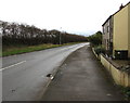
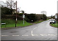
1
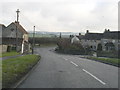
Pucklechurch, South Gloucestershire
Since the 1940s the road priorities at this junction have changed. The road to Hinton now goes off left whilst the mainroad rounds the bend to Abson and Wick. The reason is the large number of houses built to the south of the village in the 1960s and 1970s.
Image: © ChurchCrawler
Taken: 27 Dec 2005
0.01 miles
2
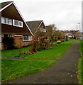
Path past Maple Walk houses, Pucklechurch
Viewed from Oaktree Avenue.
Image: © Jaggery
Taken: 5 Feb 2016
0.02 miles
3
Feltham Road towards Abson Road, Pucklechurch
Viewed from the corner of Castle Road. http://www.geograph.org.uk/photo/4817069
Image: © Jaggery
Taken: 5 Feb 2016
0.02 miles
4
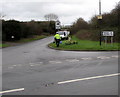
Distances from Pucklechurch
The sign pointing along Feltham Road shows 2 (miles) to Hinton, 2½ to Dyrham.
Image: © Jaggery
Taken: 5 Feb 2016
0.02 miles
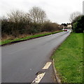
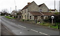
5
Abson Road, Pucklechurch
Road at the eastern edge of Pucklechurch, viewed from near the Feltham Road junction.
Image: © Jaggery
Taken: 5 Feb 2016
0.02 miles
6
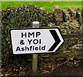
HMP & YOI Ashfield this way, Pucklechurch
The direction sign is alongside Abson Road Pucklechurch, facing the Feltham Road junction.
HMP = Her Majesty's Prison. YOI = Young Offender Institution.
Image: © Jaggery
Taken: 5 Feb 2016
0.02 miles
7
Traffic visibility mirror, Pucklechurch
Alongside Abson Road near Little Court (the house).
Image: © Jaggery
Taken: 5 Feb 2016
0.03 miles
8
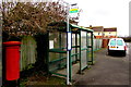
Maple Walk bus stop and shelter, Pucklechurch
Alongside Oaktree Avenue near the Abson Road junction.
The sign shows that this stop is for buses towards Tetbury, Westerleigh, Yate.
Image: © Jaggery
Taken: 5 Feb 2016
0.03 miles
9
Junction of Feltham Road and Abson Road, Pucklechurch
This is the southwest end of Feltham Road, at the Abson Road junction.
No vehicles heavier than 7.5 tonnes on Feltham Road, except for access.
Image: © Jaggery
Taken: 5 Feb 2016
0.04 miles
10
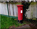
Queen Elizabeth II pillarbox, Oaktree Avenue, Pucklechurch
Located here. http://www.geograph.org.uk/photo/4816676
Image: © Jaggery
Taken: 5 Feb 2016
0.04 miles