IMAGES TAKEN NEAR TO
Westerleigh Road, BRISTOL, BS16 9RB
Introduction
This page details the photographs taken nearby to Westerleigh Road, BS16 9RB by members of the Geograph project.
The Geograph project started in 2005 with the aim of publishing, organising and preserving representative images for every square kilometre of Great Britain, Ireland and the Isle of Man.

There are currently over 7.5m images from over14,400 individuals and you can help contribute to the project by visiting https://www.geograph.org.uk
Image Map (Loading...)


Getting Data...Please wait
Leaflet Map data © OpenStreetMap
Images are licensed for reuse under creativecommons.org/licenses/by-sa/2.0
Notes
- Clicking on the map will re-center to the selected point.
- The higher the marker number, the further away the image location is from the centre of the postcode.
Image Listing (160 Images Found)
Images are licensed for reuse under creativecommons.org/licenses/by-sa/2.0
Image
Details
Distance
1
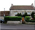
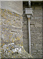
Grade II listed Church Farm Pucklechurch
Viewed across Westerleigh Road. The house named Church Farm is a
former farmhouse dating from the mid 17th century. Grade II listed in 1952.
Image: © Jaggery
Taken: 5 Feb 2016
0.01 miles
2
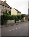
Warning sign, Westerleigh Road, Pucklechurch
The sign alongside the B4465 Westerleigh Road warns
that oncoming vehicles may be in the middle of the road ahead.
Image: © Jaggery
Taken: 5 Feb 2016
0.01 miles
3
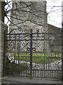
Lest we forget?
The gates to St Thomas a Becket church clearly recall the losses of the world wars. See Image] for a longer view of the church.
Image: © Neil Owen
Taken: 7 Feb 2013
0.01 miles
4
Pucklechurch (Glos) St Thomas a Becket church
A little bit overexposed - the first picture ever taken with my digital camera!
Image: © ChurchCrawler
Taken: 27 Aug 2001
0.02 miles
5
St Thomas a Becket benchmark
A cutmark, as listed in the Benchmark Database: http://www.bench-marks.org.uk/bm47121 , on the south face of Pucklechurch's main church. The mark dates from the nineteenth century, but the church also happens to have a flush bracket further to the east - see Image
Image: © Neil Owen
Taken: 7 Feb 2013
0.02 miles
6
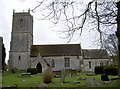
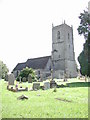
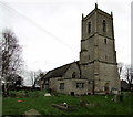
St Thomas a Becket
Pucklechurch is largely centred around the old church. It was founded over 600 years ago (and dedicated to St Thomas after his murder in 1170), and retains a number of ancient features. Of a more recent nature, the church unusually also has two benchmarks on the southern flanks - see Image] and Image Also see Image] for the gates.
Image: © Neil Owen
Taken: 7 Feb 2013
0.02 miles
7
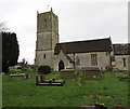
St Thomas ? Becket church, Pucklechurch
Part of the Church of England Diocese of Bristol, the church has Norman origins, dating largely from the 13th century. The tower is 14th century. There were two major restorations in the 19th century. The building was Grade I listed in August 1985.
Image: © Jaggery
Taken: 5 Feb 2016
0.02 miles
8
14th century church tower, Pucklechurch
The tower is on the west side of the Grade I listed St Thomas à Becket church, Pucklechurch. http://www.geograph.org.uk/photo/5201060
Image: © Jaggery
Taken: 5 Feb 2016
0.02 miles
9
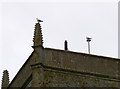
How's the weather with you?
A couple of weathergulls on top of St Thomas a Becket tower.
Cloudy, winds light southwesterly, temperatures up to nine Celsius, becoming fresher; rain later...
Image: © Neil Owen
Taken: 7 Feb 2013
0.02 miles
10

Parish church of St Thomas A Becket, Pucklechurch
Viewed from the southern edge of the churchyard on Westerleigh Road.
Image: © Simon Mortimer
Taken: 4 May 2009
0.03 miles