IMAGES TAKEN NEAR TO
Homefield Road, BRISTOL, BS16 9QD
Introduction
This page details the photographs taken nearby to Homefield Road, BS16 9QD by members of the Geograph project.
The Geograph project started in 2005 with the aim of publishing, organising and preserving representative images for every square kilometre of Great Britain, Ireland and the Isle of Man.

There are currently over 7.5m images from over14,400 individuals and you can help contribute to the project by visiting https://www.geograph.org.uk
Image Map (Loading...)


Getting Data...Please wait
Leaflet Map data © OpenStreetMap
Images are licensed for reuse under creativecommons.org/licenses/by-sa/2.0
Notes
- Clicking on the map will re-center to the selected point.
- The higher the marker number, the further away the image location is from the centre of the postcode.
Image Listing (138 Images Found)
Images are licensed for reuse under creativecommons.org/licenses/by-sa/2.0
Image
Details
Distance
1
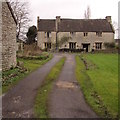
South side of Grade II listed Crump House, Pucklechurch
The house was originally a farmhouse, built in 1624. Grade II listed in 1995.
Image: © Jaggery
Taken: 5 Feb 2016
0.02 miles
2
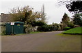
The Poplars electricity substation, Pucklechurch
The Western Power Distribution (South West) electricity substation is the cabinet on the left,
located in the car park of the Poplars retirement flats.
Image: © Jaggery
Taken: 5 Feb 2016
0.03 miles
3
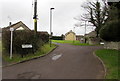
Access road to the Homefield Centre, Pucklechurch
Side road from the B4465 Shortwood Road to the Homefield Centre. http://www.geograph.org.uk/photo/4868119
Image: © Jaggery
Taken: 5 Feb 2016
0.04 miles
4
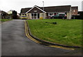
Homefield Centre, Pucklechurch
Set back from the north side of the B4465 Shortwood Road. The Homefield Centre is used by various village groups, such as the Women's Institute and the Happy Circle which provides activities and outings for older residents of Pucklechurch.
Image: © Jaggery
Taken: 5 Feb 2016
0.05 miles
5

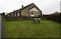
Shortwood Road bungalows, Pucklechurch
Northeast of the Homefield Road junction. Originally, bungalow was used in English for a lightly-built house,
with a veranda and one storey. In current UK usage it is a convenient word for any one-storey dwelling.
Image: © Jaggery
Taken: 5 Feb 2016
0.05 miles
6
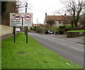
Weight restrictions sign, Shortwood Road, Pucklechurch
Facing vehicles on the B4465 approaching the junction in the centre of the village.
Image: © Jaggery
Taken: 5 Feb 2016
0.05 miles
7
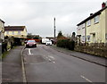
Homefield Road, Pucklechurch
Looking north along Homefield Road from the corner of the B4465 Shortwood Road.
Image: © Jaggery
Taken: 5 Feb 2016
0.05 miles
8
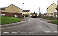
Homefield Road, Pucklechurch
Viewed across the B4465 Shortwood Road. The sign on the left shows
that Homefield Road leads to Poplar Road, Orchard Road and Queens Road.
Image: © Jaggery
Taken: 5 Feb 2016
0.06 miles
9
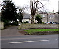
Entrance to Grade II listed The Poplars, Pucklechurch
From the B4465 Shortwood Road. The early 18th century house http://www.geograph.org.uk/photo/4868090 was Grade II listed in 1985.
Image: © Jaggery
Taken: 5 Feb 2016
0.07 miles
10
Bench and bungalows, Pucklechurch
Above the B4465 Shortwood Road.
Image: © Jaggery
Taken: 5 Feb 2016
0.07 miles