IMAGES TAKEN NEAR TO
Carsons Road, BRISTOL, BS16 9LW
Introduction
This page details the photographs taken nearby to Carsons Road, BS16 9LW by members of the Geograph project.
The Geograph project started in 2005 with the aim of publishing, organising and preserving representative images for every square kilometre of Great Britain, Ireland and the Isle of Man.

There are currently over 7.5m images from over14,400 individuals and you can help contribute to the project by visiting https://www.geograph.org.uk
Image Map (Loading...)


Getting Data...Please wait
Leaflet Map data © OpenStreetMap
Images are licensed for reuse under creativecommons.org/licenses/by-sa/2.0
Notes
- Clicking on the map will re-center to the selected point.
- The higher the marker number, the further away the image location is from the centre of the postcode.
Image Listing (3 Images Found)
Images are licensed for reuse under creativecommons.org/licenses/by-sa/2.0
Image
Details
Distance
1
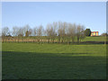
A long shot down the hill
A view across what was Shortwood Lodge Golf Club's course. The club folded last year and the fairways are now growing back into coarse. Lodge Farm overlooks the sad sight.
Image: © Neil Owen
Taken: 20 Jan 2020
0.11 miles
2
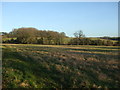
Open ground near Hanging Wood
Largely open grassland with the woodlands on the horizon.
Image: © Neil Owen
Taken: 20 Jan 2020
0.19 miles
3
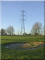
The bunker is becoming the green
Having fallen into disuse now, the fairways are growing wild and the bunkers show signs of returning to their natural state. The actual green is just ahead but is almost indistinguishable from the rest of the grass.
Image: © Neil Owen
Taken: 20 Jan 2020
0.23 miles