IMAGES TAKEN NEAR TO
Brook Road, BRISTOL, BS16 9DY
Introduction
This page details the photographs taken nearby to Brook Road, BS16 9DY by members of the Geograph project.
The Geograph project started in 2005 with the aim of publishing, organising and preserving representative images for every square kilometre of Great Britain, Ireland and the Isle of Man.

There are currently over 7.5m images from over14,400 individuals and you can help contribute to the project by visiting https://www.geograph.org.uk
Image Map (Loading...)


Getting Data...Please wait
Leaflet Map data © OpenStreetMap
Images are licensed for reuse under creativecommons.org/licenses/by-sa/2.0
Notes
- Clicking on the map will re-center to the selected point.
- The higher the marker number, the further away the image location is from the centre of the postcode.
Image Listing (2 Images Found)
Images are licensed for reuse under creativecommons.org/licenses/by-sa/2.0
Image
Details
Distance
1
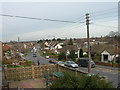
Westerleigh Road, Downend
This is the view looking down westerleigh Road towards the Avon Ring Road. You can see the Huntsman Pub.
Image: © Alice Hall
Taken: 12 Mar 2007
0.15 miles
2
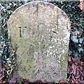
Old Boundary Marker
Boundary Marker against the northern wall of Mangotsfield Cemetery, Westerleigh Road. Downend and Bromley Heath parish. Inscribed F S on its centre face.
Milestone Society National ID: GL_DOWN01bm
Image: © S Kosciow
Taken: 23 Dec 2019
0.25 miles