IMAGES TAKEN NEAR TO
Cherrytree Court, BRISTOL, BS16 9BF
Introduction
This page details the photographs taken nearby to Cherrytree Court, BS16 9BF by members of the Geograph project.
The Geograph project started in 2005 with the aim of publishing, organising and preserving representative images for every square kilometre of Great Britain, Ireland and the Isle of Man.

There are currently over 7.5m images from over14,400 individuals and you can help contribute to the project by visiting https://www.geograph.org.uk
Image Map
Images are licensed for reuse under creativecommons.org/licenses/by-sa/2.0
Notes
- Clicking on the map will re-center to the selected point.
- The higher the marker number, the further away the image location is from the centre of the postcode.
Image Listing (119 Images Found)
Images are licensed for reuse under creativecommons.org/licenses/by-sa/2.0
Image
Details
Distance
1
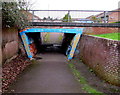
Southeast side of a pedestrian underpass, Pucklechurch
Under Oaktree Avenue.
Image: © Jaggery
Taken: 5 Feb 2016
0.02 miles
2

Northwest side of a pedestrian underpass, Pucklechurch
Under Oaktree Avenue.
Image: © Jaggery
Taken: 5 Feb 2016
0.03 miles
3
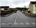
Oaktree Avenue, Pucklechurch
Viewed across Abson Road.
Image: © Jaggery
Taken: 5 Feb 2016
0.03 miles
4
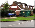
Oaktree Avenue electricity substation, Pucklechurch
The dark green cabinet on the corner of Oaktree Avenue and Holly Close is a Western Power Distribution (South West) electricity substation. Its identifier is 2305 OAKTREE AVE P S/S.
Image: © Jaggery
Taken: 5 Feb 2016
0.03 miles
5
Holly Close, Pucklechurch
On the southeast side of Oaktree Avenue.
Image: © Jaggery
Taken: 5 Feb 2016
0.03 miles
6
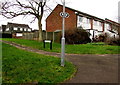
Footpath sign, Pucklechurch
Facing this underpass http://www.geograph.org.uk/photo/4816989, the white on black sign is on a lamppost. Behind the lamppost, a name sign shows CEDAR WAY.
Image: © Jaggery
Taken: 5 Feb 2016
0.04 miles
7
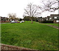
Grass, trees and houses, Pucklechurch
Oaktree Avenue is on the left.
Image: © Jaggery
Taken: 5 Feb 2016
0.05 miles
8
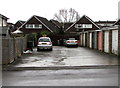
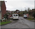
Oaktree Avenue lockup garages, Pucklechurch
Between Oaktree Avenue and Holly Close.
Image: © Jaggery
Taken: 5 Feb 2016
0.05 miles
9
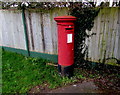
Queen Elizabeth II pillarbox, Oaktree Avenue, Pucklechurch
Located here. http://www.geograph.org.uk/photo/4816676
Image: © Jaggery
Taken: 5 Feb 2016
0.06 miles
10
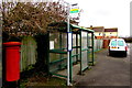
Maple Walk bus stop and shelter, Pucklechurch
Alongside Oaktree Avenue near the Abson Road junction.
The sign shows that this stop is for buses towards Tetbury, Westerleigh, Yate.
Image: © Jaggery
Taken: 5 Feb 2016
0.07 miles