IMAGES TAKEN NEAR TO
Oak Tree Close, BRISTOL, BS16 9AJ
Introduction
This page details the photographs taken nearby to Oak Tree Close, BS16 9AJ by members of the Geograph project.
The Geograph project started in 2005 with the aim of publishing, organising and preserving representative images for every square kilometre of Great Britain, Ireland and the Isle of Man.

There are currently over 7.5m images from over14,400 individuals and you can help contribute to the project by visiting https://www.geograph.org.uk
Image Map
Images are licensed for reuse under creativecommons.org/licenses/by-sa/2.0
Notes
- Clicking on the map will re-center to the selected point.
- The higher the marker number, the further away the image location is from the centre of the postcode.
Image Listing (3 Images Found)
Images are licensed for reuse under creativecommons.org/licenses/by-sa/2.0
Image
Details
Distance
1
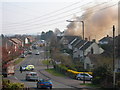
Huntsman Pub Fire
This was taken 7th April at about 11am. The Huntsman Pub on Westerleigh road is on fire and was eventually gutted. The young family who lived in it escaped safely.
This fire went on for about 5 hours and the road was closed off for the whole day.
Image: © Alice Hall
Taken: 7 Apr 2007
0.17 miles
2
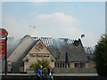
Huntsman Pub Fire
Here is a close up of the Huntsman Pub on fire. As you can see, the roof has been completely destroyed. You can faintly see the fire crew on a hydraulic platform behind the building trying to put out the fire.
Image: © Alice Hall
Taken: 7 Apr 2007
0.18 miles
3
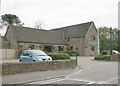
2007 : The Langley Arms
User commended for food and drink http://www.pubsinthearea.co.uk/ukvillages.nsf/pubs/England/Emersons+Green-Bristol+City?open&body=pubs
Image: © Maurice Pullin
Taken: 20 Oct 2007
0.22 miles