IMAGES TAKEN NEAR TO
Viola Way, BRISTOL, BS16 7LL
Introduction
This page details the photographs taken nearby to Viola Way, BS16 7LL by members of the Geograph project.
The Geograph project started in 2005 with the aim of publishing, organising and preserving representative images for every square kilometre of Great Britain, Ireland and the Isle of Man.

There are currently over 7.5m images from over14,400 individuals and you can help contribute to the project by visiting https://www.geograph.org.uk
Image Map
Images are licensed for reuse under creativecommons.org/licenses/by-sa/2.0
Notes
- Clicking on the map will re-center to the selected point.
- The higher the marker number, the further away the image location is from the centre of the postcode.
Image Listing (7 Images Found)
Images are licensed for reuse under creativecommons.org/licenses/by-sa/2.0
Image
Details
Distance
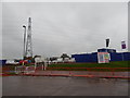
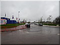
2
Lyde Green (housing estate)
This part is presumably also just in Pucklechurch parish. See also Image for info on parish boundaries in the hamlet.
Image: © Hamish Griffin
Taken: 11 Nov 2014
0.12 miles
3
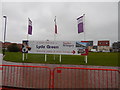
Lyde Green sign
This bit is presumably not in Mangotsfield Rural, although it is difficult to tell.
Image: © Hamish Griffin
Taken: 11 Nov 2014
0.13 miles
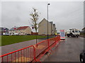
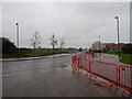
4
Street in Lyde Green
Left at the junction goes to the A4174.
Image: © Hamish Griffin
Taken: 11 Nov 2014
0.13 miles
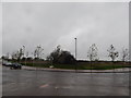
5
Lyde Green (housing estate)
Looking towards the A4174.
Image: © Hamish Griffin
Taken: 11 Nov 2014
0.15 miles
6
Lyde Green (housing estate)
Looking north towards the hamlet.
Image: © Hamish Griffin
Taken: 11 Nov 2014
0.17 miles
7
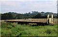
2011 : Making hay south of Howsmoor Lane
Near Hallen Farm.
The grass has been cut and is being raked into ridges for drying. A trailer waits to take it away when baled. (could be for silage)
Image: © Maurice Pullin
Taken: 2 Sep 2011
0.22 miles