IMAGES TAKEN NEAR TO
Johnson Road, BRISTOL, BS16 7JQ
Introduction
This page details the photographs taken nearby to Johnson Road, BS16 7JQ by members of the Geograph project.
The Geograph project started in 2005 with the aim of publishing, organising and preserving representative images for every square kilometre of Great Britain, Ireland and the Isle of Man.

There are currently over 7.5m images from over14,400 individuals and you can help contribute to the project by visiting https://www.geograph.org.uk
Image Map (Loading...)


Getting Data...Please wait
Leaflet Map data © OpenStreetMap
Images are licensed for reuse under creativecommons.org/licenses/by-sa/2.0
Notes
- Clicking on the map will re-center to the selected point.
- The higher the marker number, the further away the image location is from the centre of the postcode.
Image Listing (32 Images Found)
Images are licensed for reuse under creativecommons.org/licenses/by-sa/2.0
Image
Details
Distance
1
Emerson's Green
Looking down Shackel Hendy Mews.
Very quiet roads, hardly met a single pedestrian along my journey.
Image: © Linda Bailey
Taken: 24 May 2006
0.01 miles
2
Snail slow
An illustrated traffic sign with a variety of snails to add emphasis.
Image: © Neil Owen
Taken: 24 Jan 2023
0.11 miles
3
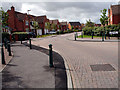
2011 : B4465 traffic calming on Cossham Street
Heading toward Pucklechurch. Mangotsfield behind.
Image: © Maurice Pullin
Taken: 2 Sep 2011
0.14 miles
4
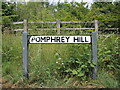
Getting too much sun?
The sign for Pomphrey Hill appears to have suffered from a little too much heat.
Image: © Neil Owen
Taken: 24 Jun 2021
0.15 miles
5
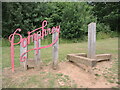
Pomphrey script
Pomphrey Hill is now a place for lots of different sport and leisure activities. The sign and timbers are all part of the appearance.
Image: © Neil Owen
Taken: 24 Jun 2021
0.15 miles
6
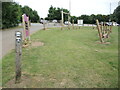
The activities start right by the car park
Once parked up, visitors are immediately presented with some fitness equipment as they go down to the pavilion. Also included are some oversized puzzles for the little ones.
Image: © Neil Owen
Taken: 24 Jun 2021
0.15 miles
7
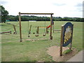
Perform at Pomphrey Hill
Some of the outdoor equipment that anyone can use. Beyond is the wicket of a cricket club; beyond that is a football pitch.
Image: © Neil Owen
Taken: 24 Jun 2021
0.15 miles
8
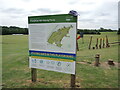
Staying safe on Pomphrey Hill
A sign gives lots of information and advice for using the outdoor facilities.
Image: © Neil Owen
Taken: 24 Jun 2021
0.15 miles
9
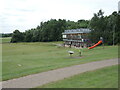
Pomphrey Hill sports fround
The recreation area was founded in 2011 and is run by Pomphrey Hill Community Sports Association. The pavilion offers a number of indoor spaces and kitchen facilities.
Image: © Neil Owen
Taken: 24 Jun 2021
0.16 miles
10
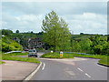
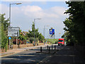
B4465 approaching Shortwood
A realigned road with a traffic-calming island just before the bridge over the A4174 Bristol outer ring road.
The Bridge pub can be seen beyond that bridge.
Image: © Jonathan Billinger
Taken: 19 May 2009
0.16 miles