IMAGES TAKEN NEAR TO
Johnson Road, BRISTOL, BS16 7JG
Introduction
This page details the photographs taken nearby to Johnson Road, BS16 7JG by members of the Geograph project.
The Geograph project started in 2005 with the aim of publishing, organising and preserving representative images for every square kilometre of Great Britain, Ireland and the Isle of Man.

There are currently over 7.5m images from over14,400 individuals and you can help contribute to the project by visiting https://www.geograph.org.uk
Image Map
Images are licensed for reuse under creativecommons.org/licenses/by-sa/2.0
Notes
- Clicking on the map will re-center to the selected point.
- The higher the marker number, the further away the image location is from the centre of the postcode.
Image Listing (6 Images Found)
Images are licensed for reuse under creativecommons.org/licenses/by-sa/2.0
Image
Details
Distance
1
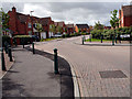
Emerson's Green
Looking down Shackel Hendy Mews.
Very quiet roads, hardly met a single pedestrian along my journey.
Image: © Linda Bailey
Taken: 24 May 2006
0.11 miles
2
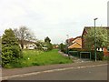
Footpath in Emersons Green housing estate
This footpath off Pinkers Mead road leads North to the local food supermarket
Image: © Ali Moyle
Taken: 5 May 2014
0.16 miles
3
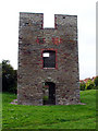
Site of disused mine in Emerson's Green
The area immediately surrounding this building is all a new housing estate.
This is the engine house of Church Farm Colliery, one of the many former mines in this area.
Image: © Linda Bailey
Taken: 12 Sep 2006
0.19 miles
4
Snail slow
An illustrated traffic sign with a variety of snails to add emphasis.
Image: © Neil Owen
Taken: 24 Jan 2023
0.23 miles
5
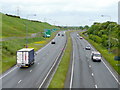
A4174 at Shortwood
The Bristol outer ring road, looking north.
Image: © Jonathan Billinger
Taken: 19 May 2009
0.23 miles
6
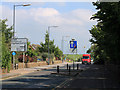
2011 : B4465 traffic calming on Cossham Street
Heading toward Pucklechurch. Mangotsfield behind.
Image: © Maurice Pullin
Taken: 2 Sep 2011
0.24 miles