IMAGES TAKEN NEAR TO
Harrison Close, BRISTOL, BS16 7HB
Introduction
This page details the photographs taken nearby to Harrison Close, BS16 7HB by members of the Geograph project.
The Geograph project started in 2005 with the aim of publishing, organising and preserving representative images for every square kilometre of Great Britain, Ireland and the Isle of Man.

There are currently over 7.5m images from over14,400 individuals and you can help contribute to the project by visiting https://www.geograph.org.uk
Image Map (Loading...)


Getting Data...Please wait
Leaflet Map data © OpenStreetMap
Images are licensed for reuse under creativecommons.org/licenses/by-sa/2.0
Notes
- Clicking on the map will re-center to the selected point.
- The higher the marker number, the further away the image location is from the centre of the postcode.
Image Listing (5 Images Found)
Images are licensed for reuse under creativecommons.org/licenses/by-sa/2.0
Image
Details
Distance
1
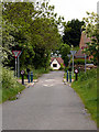
Emersons Green Lane
This junction of Emersons Green Lane and Guest Avenue, is a cross-roads at which you must go straight on, no-matter which direction you approach it from, due to the narrowness and the bollards. View of the same junction from a different direction Image
The lane running in this direction appears on maps 100 years ago, whereas the road crossing it is much newer.
Image: © Linda Bailey
Taken: 24 May 2006
0.09 miles
2
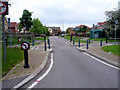
Guest Avenue Crossroads
Another view of the same junction of Guest Avenue with Emersons Green Lane Image at which you must go straight on at the crossroads due to the design of the junction.
Image: © Linda Bailey
Taken: 24 May 2006
0.09 miles
3
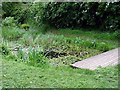
Vinny Green Wildlife Pond
This pond has been fenced off.
Image: © Linda Bailey
Taken: 24 May 2006
0.20 miles
5
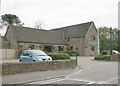
2007 : The Langley Arms
User commended for food and drink http://www.pubsinthearea.co.uk/ukvillages.nsf/pubs/England/Emersons+Green-Bristol+City?open&body=pubs
Image: © Maurice Pullin
Taken: 20 Oct 2007
0.25 miles