IMAGES TAKEN NEAR TO
Brook Office Park, BRISTOL, BS16 7FL
Introduction
This page details the photographs taken nearby to Brook Office Park, BS16 7FL by members of the Geograph project.
The Geograph project started in 2005 with the aim of publishing, organising and preserving representative images for every square kilometre of Great Britain, Ireland and the Isle of Man.

There are currently over 7.5m images from over14,400 individuals and you can help contribute to the project by visiting https://www.geograph.org.uk
Image Map
Images are licensed for reuse under creativecommons.org/licenses/by-sa/2.0
Notes
- Clicking on the map will re-center to the selected point.
- The higher the marker number, the further away the image location is from the centre of the postcode.
Image Listing (8 Images Found)
Images are licensed for reuse under creativecommons.org/licenses/by-sa/2.0
Image
Details
Distance
1
The Brooms on Emerald Green industrial area, Emerson Green near Bristol
The dragon fly sculpture is just visible.
Image: © Steve Fareham
Taken: 9 Dec 2009
0.09 miles
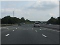
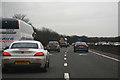
3
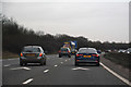
South Gloucestershire : M4 Motorway
The M4 Motorway between Junction 19 (Hambrook Interchange) and Junction 18 (Tormarton Interchange).
Image: © Lewis Clarke
Taken: 23 Mar 2018
0.12 miles
5
South Gloucestershire : M4 Motorway
The M4 Motorway between Junction 19 (Hambrook Interchange) and Junction 18 (Tormarton Interchange).
Image: © Lewis Clarke
Taken: 23 Mar 2018
0.14 miles
6
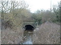
Rather overgrown Folly Bridge over Folly Brook
At the back of a pub car park
Image: © John Phillips
Taken: 23 Mar 2006
0.22 miles
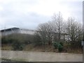
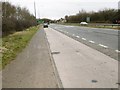
7
Folly Brook Road
Looking from the roundabout by The Folly. The road crosses the Folly Brook before it reaches the roundabout in the distance, just downstream from the old Folly Bridge.
Image: © Derek Harper
Taken: 22 Nov 2013
0.22 miles
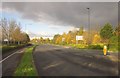
8
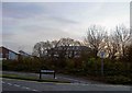
Emerson's Green, lay-by
On Bristol Ring Road, southbound.
Image: © Mike Faherty
Taken: 8 Mar 2015
0.25 miles