IMAGES TAKEN NEAR TO
Bampton Croft, BRISTOL, BS16 7EN
Introduction
This page details the photographs taken nearby to Bampton Croft, BS16 7EN by members of the Geograph project.
The Geograph project started in 2005 with the aim of publishing, organising and preserving representative images for every square kilometre of Great Britain, Ireland and the Isle of Man.

There are currently over 7.5m images from over14,400 individuals and you can help contribute to the project by visiting https://www.geograph.org.uk
Image Map (2 Images)


Getting Data...Please wait
Leaflet Map data © OpenStreetMap
Images are licensed for reuse under creativecommons.org/licenses/by-sa/2.0
Notes
- Clicking on the map will re-center to the selected point.
- The higher the marker number, the further away the image location is from the centre of the postcode.
Image Listing (2 Images Found)
Images are licensed for reuse under creativecommons.org/licenses/by-sa/2.0
Image
Details
Distance
1
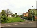
Footpath in Emersons Green housing estate
This footpath off Pinkers Mead road leads North to the local food supermarket
Image: © Ali Moyle
Taken: 5 May 2014
0.06 miles
2
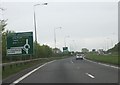
Approaching Dramway Roundabout
Approaching Dramway Roundabout on the Bristol Ring Road from the north-east.
Image: © Ruth Riddle
Taken: 4 May 2012
0.24 miles