IMAGES TAKEN NEAR TO
Westerleigh Road, BRISTOL, BS16 7AN
Introduction
This page details the photographs taken nearby to Westerleigh Road, BS16 7AN by members of the Geograph project.
The Geograph project started in 2005 with the aim of publishing, organising and preserving representative images for every square kilometre of Great Britain, Ireland and the Isle of Man.

There are currently over 7.5m images from over14,400 individuals and you can help contribute to the project by visiting https://www.geograph.org.uk
Image Map
Images are licensed for reuse under creativecommons.org/licenses/by-sa/2.0
Notes
- Clicking on the map will re-center to the selected point.
- The higher the marker number, the further away the image location is from the centre of the postcode.
Image Listing (8 Images Found)
Images are licensed for reuse under creativecommons.org/licenses/by-sa/2.0
Image
Details
Distance
1
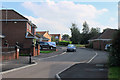
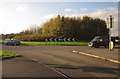
2011 : Thomas Avenue, Emerson's Green
Or it may be Vinny Green.
A housing development from around the turn of the century.
Warning to strangers, venture into this area without a GPS and you may be condemned to wander around for ever like the flying Dutchman.
Image: © Maurice Pullin
Taken: 2 Sep 2011
0.16 miles
2
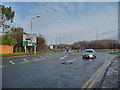
Lyde Green Roundabout
The junction of Westerleigh Road with the A4174 north Bristol ring road.
Image: © John Allan
Taken: 5 Feb 2012
0.17 miles
3
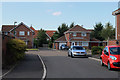
2011 : Thomas Avenue. New England, Mangotsfield
Or it may be Emerson's Green, or Vinny Green perhaps.
Image: © Maurice Pullin
Taken: 2 Sep 2011
0.17 miles
4
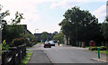
2011 : Emersons Way looking west
Adderley Gate is to the left with a post box opposite.
Image: © Maurice Pullin
Taken: 2 Sep 2011
0.22 miles
5
Lyde Green roundabout
Seen from Howsmoor Lane / Westerleigh Lane.
Image: © Derek Harper
Taken: 22 Nov 2013
0.23 miles
6
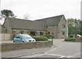
2007 : The Langley Arms
User commended for food and drink http://www.pubsinthearea.co.uk/ukvillages.nsf/pubs/England/Emersons+Green-Bristol+City?open&body=pubs
Image: © Maurice Pullin
Taken: 20 Oct 2007
0.23 miles
7
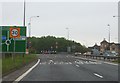
Approaching Lyde Green Roundabout
Approaching Lyde Green Roundabout on the Bristol Ring Road from the north-west.
Image: © Ruth Riddle
Taken: 4 May 2012
0.23 miles
8
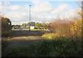
Howsmoor Lane
Showing the barrier referred to in Image In the background is the Lyde Green roundabout on the A4174.
Image: © Derek Harper
Taken: 22 Nov 2013
0.25 miles