IMAGES TAKEN NEAR TO
Aintree Drive, BRISTOL, BS16 6SY
Introduction
This page details the photographs taken nearby to Aintree Drive, BS16 6SY by members of the Geograph project.
The Geograph project started in 2005 with the aim of publishing, organising and preserving representative images for every square kilometre of Great Britain, Ireland and the Isle of Man.

There are currently over 7.5m images from over14,400 individuals and you can help contribute to the project by visiting https://www.geograph.org.uk
Image Map (Loading...)


Getting Data...Please wait
Leaflet Map data © OpenStreetMap
Images are licensed for reuse under creativecommons.org/licenses/by-sa/2.0
Notes
- Clicking on the map will re-center to the selected point.
- The higher the marker number, the further away the image location is from the centre of the postcode.
Image Listing (21 Images Found)
Images are licensed for reuse under creativecommons.org/licenses/by-sa/2.0
Image
Details
Distance
1
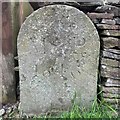
Old Boundary Marker on Church Lane, Bromley Heath
Parish Boundary Marker in the front garden wall of number 55 on the southwest side of Church Lane, Bromley Heath. On the former boundary of Mangotsfield and Westerleigh parish but now entirely in Downend and Bromley Heath parish. Inscribed M P / 1846.
Milestone Society National ID: GL_DOWN03pb
Image: © S Kosciow
Taken: 31 Jul 2021
0.07 miles
2
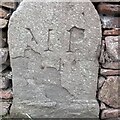
Old Boundary Marker on Church Lane, Bromley Heath
Parish Boundary Marker in the front garden wall of number 51 on the southwest side of Church Lane, Bromley Heath. On the former boundary of Mangotsfield and Westerleigh parish but now entirely in Downend and Bromley Heath parish. Inscribed M P / (18? illegible)46.
Milestone Society National ID: GL_DOWN02pb
Image: © S Kosciow
Taken: 31 Jul 2021
0.08 miles
3
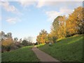
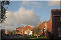
Path, Leap valley
Footpath PMR/1 running along the slope of the valley, with autumnal trees in low afternoon sun.
Image: © Derek Harper
Taken: 22 Nov 2013
0.10 miles
4
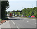
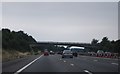
2011 : A4174 Avon Ring Road
This stretch of the Avon "Ring" Road is in a sort of limbo between Moorend, Downend, Bromley Heath and Blackhorse. You pays yer money and you takes yer choice.
A Sainsbury delivery vehicle is about to pass under a footbridge at the end of Aintree Drive. Marked on OS Explorer map 155 as a bridleway so you could take horses over there.
Named the Avon Ring Road when Bristol was renamed "Avon". Common sense has since prevailed and Bristol was renamed back again, but the name has stuck.
Image: © Maurice Pullin
Taken: 2 May 2011
0.12 miles
5
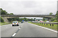
A sad spot for a family
From the footbridge over the A4174 Bristol Ring road at Downend. Note the flowers by the first lamp post
Image: © John Phillips
Taken: 22 Mar 2006
0.12 miles
6
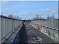
Can you spot the speed camera?
Footbridge over both the Bristol northern ring road [A4174] and the M4
Image: © John Phillips
Taken: 22 Mar 2006
0.13 miles
7
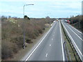
M4 near Downend, Bristol
Westbound between junctions 18 and 19
Image: © MrC
Taken: 20 Aug 2010
0.13 miles
8
Beverley Avenue, Downend
Another view along the cul-de-sac shown in Image
Image: © Derek Harper
Taken: 22 Nov 2013
0.14 miles
9
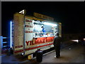
Bristol: Yilmaz Kebabs van on the Ring Road
A fast-food outlet in a lay-by on the eastbound carriageway of the A4174 Bristol Ring Road. It is open seven days a week, from 5pm to 1am and is pictured here at eleven o'clock on a Sunday night.
Image: © Chris Downer
Taken: 19 Feb 2012
0.15 miles