IMAGES TAKEN NEAR TO
Lytchet Drive, BRISTOL, BS16 6SA
Introduction
This page details the photographs taken nearby to Lytchet Drive, BS16 6SA by members of the Geograph project.
The Geograph project started in 2005 with the aim of publishing, organising and preserving representative images for every square kilometre of Great Britain, Ireland and the Isle of Man.

There are currently over 7.5m images from over14,400 individuals and you can help contribute to the project by visiting https://www.geograph.org.uk
Image Map (Loading...)


Getting Data...Please wait
Leaflet Map data © OpenStreetMap
Images are licensed for reuse under creativecommons.org/licenses/by-sa/2.0
Notes
- Clicking on the map will re-center to the selected point.
- The higher the marker number, the further away the image location is from the centre of the postcode.
Image Listing (11 Images Found)
Images are licensed for reuse under creativecommons.org/licenses/by-sa/2.0
Image
Details
Distance
1
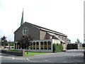
Downend (Glos) St Augustine of Canterbury RC Church
Really a suburb of Bristol, but South Glos people are fiercely independent. This Catholic Church is a notable feature in this sea of 1950s and 1960s housing.
Image: © ChurchCrawler
Taken: Unknown
0.09 miles
2
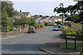
2011 : Westbourne Road, Downend, Bristol
A residential road between Badminton Road and Westerleigh Road.
Fairly modern development.
Image: © Maurice Pullin
Taken: 2 Aug 2011
0.13 miles
3
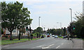
2011 : A432 Badminton Road entering Downend
With pedestrian crossing.
The extra lane directs traffic into Westbourne Road.
Image: © Maurice Pullin
Taken: 2 Aug 2011
0.17 miles
4
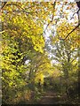
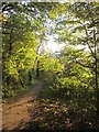
Path, Leap valley
Looking in the other direction from the same spot as Image
Image: © Derek Harper
Taken: 22 Nov 2013
0.17 miles
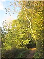
5
Path, Leap valley
Another fetching view of autumn sun along the stretch of path shown in Image
Image: © Derek Harper
Taken: 22 Nov 2013
0.18 miles
6
Path, Leap valley
Running close to the Leap Brook near Chine View. For the view in the other direction, see Image
Image: © Derek Harper
Taken: 22 Nov 2013
0.20 miles
7
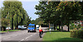
2011 : Badminton Road, Downend, Bristol
The A432 runs parallel to the left.
Looks like an attempt to avoid the accusation of ribbon development.
Image: © Maurice Pullin
Taken: 2 Aug 2011
0.20 miles
8
2011 : A432 Badminton Road, Downend
With hot cyclist.
Heading out of Bristol toward Coalpit Heath and Chipping Sodbury.
Ribbon development from the 1920's and 30's has now extended to the Avon Ring Road and has been mostly filled in (goodbye green belt).
Image: © Maurice Pullin
Taken: 2 Aug 2011
0.21 miles
9
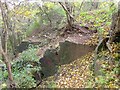
Quarry, Leap valley
In steep woodland below Leap Valley Crescent, and by footpath PMR/4.
Image: © Derek Harper
Taken: 22 Nov 2013
0.22 miles
10
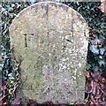
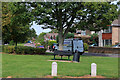
Old Boundary Marker
Boundary Marker against the northern wall of Mangotsfield Cemetery, Westerleigh Road. Downend and Bromley Heath parish. Inscribed F S on its centre face.
Milestone Society National ID: GL_DOWN01bm
Image: © S Kosciow
Taken: 23 Dec 2019
0.22 miles